
Pricing Change
New pricing for orders of material from this site will come into place shortly. Charges for supply of digital images, digitisation on demand, prints and licensing will be altered.
Eigg, Rubh' An Tangaird


Building (Prehistoric), Enclosure (Period Unassigned)
Site Name Eigg, Rubh' An Tangaird
Classification Building (Prehistoric), Enclosure (Period Unassigned)
Alternative Name(s) Galmisdale; Cnoc Leathan
Canmore ID 149414
Site Number NM48SE 33
NGR NM 47771 83459
Datum OSGB36 - NGR
Permalink http://canmore.org.uk/site/149414


- Council Highland
- Parish Small Isles
- Former Region Highland
- Former District Lochaber
- Former County Inverness-shire
NM48SE 33 centred 4775 8346
Scheduled as Galmisdale, house.
Information from Historic Scotland, scheduling document dated 23 February 2004.
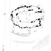
Measured Survey (29 August 2001)
RCAHMS surveyed the building at Rubh’ An Tangaird (Galmisdale) on 29 August 2001 with plane-table and alidade at a scale of 1:100. The plan was redrawn in ink and later used as the basis of an illustration that was published in 2016 at a scale of 1:250 (Hunter, fig. 3.4).
Field Visit (2001 - 2002)
This oval building is situated 230m SSE of the nearest roofed building and 260m NNW of Rubha an Tangaird point. It measures 8m from E to W by 4.3m transversely, within a stone wall that averages 2m in thickness and 0.5m in height, marked by numerous inner and outer facing stones. The entrance is to the E and is 2m in width. The closest parallels for this building are to be found among the oval prehistoric houses of Shetland, with which it shares many characteristics eg Scord of Brouster (HU25SE 26).
A secondary enclosure is attached to the S wall of the building. It measures 5.1m from E to W by 2m transversely within a wall about 1m in thickness and there is an entrance to the W. There are the remains of later lazy bed cultivation to the W.
(EIGG01 490)
Visited by RCAHMS (ARG, MFTR) 15 May 2001 and RCAHMS (AGCH) 11 October 2002
Publication Account (2002)
This oval building is situated on a terrace at the edge of later rig cultivation. It measures 8m in length by 4.3m in breadth within a wall 2m thick, faced both inside and out with large stones. The entrance, 2.1m wide, is at the east end, flanked by the remains of a flat facade. An upright stone stands on each side of the entrance at its outer edge, immediately in front of the facade, but it is not clear whether these are original features. A sub-rectangular cell built onto the outer face of the S wall, and measuring internally 6m by 2.5m is probably a much later structure.
The closest parallels for this building are to be found amongst the oval prehistoric houses on Shetland, with which it shares many characteristics. The thick, stone-faced walls with an entrance at one end are defining features of the Shetland houses. Many of them (e.g. Stanydale Temple, Benie Hoose, and Sumburgh) have stone facades and one site (Loch of Collaster) features a pair of boulders outside the entrance (admittedly set a distance of 1m from the outer wall face, but nevertheless reminiscent of the stones at Galmisdale). Most of the Shetland houses have small cells or alcoves set into their walls; no such features can be identified at Galmisdale, though most of the inner facing stones are missing and it may be that small cells would be revealed by excavation. One problem with identifying the Galmisdale building as a house, though, is the width of its entrance. A possible answer is that there was a substantial timber component. At Scord of Brouster the entrance measured 1.3m in width, but the excavator identified two possible post-holes which may have narrowed the doorway; a similar arrangement may be postulated at Galmisdale. The earliest dates from the oval houses of Shetland come from House 1 at Scord of Brouster, constructed in the late Neolithic, around 3000 BC, but the form continues in use into the Bronze Age, and with variations, into late prehistory.
While houses of this type are largely a Shetland phenomenon, one prehistoric building with a generally similar ground plan has been recorded in the Outer Hebrides. This was an oval structure discovered in sand dunes at Northton on Harris, which measured internally 8.5m by 4.2m. Occupation of the house was associated with Beaker pottery, and a single C-14 date of 3080 +/- 150BC was obtained.
Information from ‘RCAHMS Excursion Guide: Commissioners' Field Excursion, The Small Isles, 23-26 September 2002’.

