
Following the launch of trove.scot in February 2025 we are now planning the retiral of some of our webservices. Canmore will be switched off on 24th June 2025. Information about the closure can be found on the HES website: Retiral of HES web services | Historic Environment Scotland
Hall Of Ireland


Cist (Period Unassigned), Round Barrow (Prehistoric)
Site Name Hall Of Ireland
Classification Cist (Period Unassigned), Round Barrow (Prehistoric)
Alternative Name(s) Howe Of Tongue
Canmore ID 1492
Site Number HY20NE 2
NGR HY 29466 09923
Datum OSGB36 - NGR
Permalink http://canmore.org.uk/site/1492


- Council Orkney Islands
- Parish Stenness
- Former Region Orkney Islands Area
- Former District Orkney
- Former County Orkney
HY20NE 2 2945 0992.
(HY 2945 0992) Site of Tumulus {NR}
Stone Cist found AD 1858
OS 6" map, Orkney, 2nd ed., (1903).
The stone cist was 4ft long by 2ft wide and contained burnt and broken bones and ashes: around the cist was found a light substance like bone dust or ashes (probably 'cramp' - see HY21SE).
The cist was found when the ground was first cultivated, c.1858, at which time the spot was marked by a large tumulus. A slight elevation is still visible.
Name Book 1880.
A hillock of about 60ft diameter, around which burnt material can be seen. It is known to older people in the locality as 'Howe of Tongue'. In August 1928 it was under crop and could not be closely inspected. The farmer, however, stated that large stones were regularly encountered on the mound in ploughing.
Noted by Commission as 'Mound of Burnt Stones'.
RCAHMS 1946, visited August 1928.
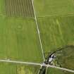
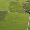
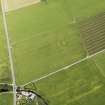
This is undoubtedly the remains of a disc barrow, much reduced by cultivation, clearly visible as a soil-mark at the time of investigation. The central mound measures about 18.0m in diameter and 0.5m high, and is surrounded by a much spread outer bank c.38.0m in diameter. It is no longer known locally as the 'Howe of Tongue'.
Surveyed at 1/2500.
Visited by OS (AC) 20 May 1966.
Field Visit (20 May 1966)
This is undoubtedly the remains of a disc barrow, much reduced by cultivation, clearly visible as a soil-mark at the time of investigation. The central mound measures about 18.0m in diameter and 0.5m high, and is surrounded by a much spread outer bank c.38.0m in diameter. It is no longer known locally as the 'Howe of Tongue'.
Surveyed at 1/2500.
Visited by OS (AC) 20 May 1966.
Field Visit (1994)
During the course of the Orkney Barrows Project, it was not possible to gain access to this mound. It was noted that there may have been some burnt material visible around the area of the mound, which had not appeared to diminish in size since the visit of the Ordnance Survey in 1966.
Information from the Orkney Barrows Project (JD), 1994

