
Pricing Change
New pricing for orders of material from this site will come into place shortly. Charges for supply of digital images, digitisation on demand, prints and licensing will be altered.
Torboll


Field System (Period Unassigned), Hut Circle(S) (Prehistoric)
Site Name Torboll
Classification Field System (Period Unassigned), Hut Circle(S) (Prehistoric)
Canmore ID 14830
Site Number NH79NW 8
NGR NH 739 990
NGR Description Centred NH 739 990
Datum OSGB36 - NGR
Permalink http://canmore.org.uk/site/14830


- Council Highland
- Parish Dornoch
- Former Region Highland
- Former District Sutherland
- Former County Sutherland
NH79NW 8 centred 739 990
(B: NH 7389 9907; C: NH 7395 9903; D: NH 7408 9914) Hut Circles (NR)
OS 6" map, (1969)
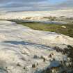
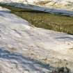
Centred at NH 739 990 in the area indicated by the RCAHMS (1911) is a settlement of five stone-walled huts (A - E) and an associated field system.
All the huts are oval with their longer axis NW-SE. With the exception of 'E', each has an entrance gap in the SE. All measurements across the huts are between wall centres.
Hut A, the best preserved, is built up on a S-facing slope and measures 14.0m by 12.5m. The outer face is visible intermittently and the inner face can be seen in the NW giving a wall thickness of 1.9m at this point. At the entrance is an earthfast stone, possibly an inner facing stone, suggesting that the wall widens here to 2.7m. Supporting the S arc of the hut is a considerable build-up, which includes living rock and occasional set stones.
'B', set into a slope, measures c.12.5m by 10.5m with a wall spread to c.2.5m all round.
'C' measures c.14.0m by 12.5m with the wall spread to an indefinite width.
'D' is probably the hut noted by the RCAHMS measuring 32' x 26'. It is built-up on a SE-facing slope and measures c.11.5m by 9.0m with the wall spread to c. 2.0m. Occasional outer facing stones are discernible. The irregular mound, 30' x 16', seen by the RCAHMS is no longer evident and the "hut circle" 40' to the N is a natural formation.
'E', built up on a SE slope, is greatly reduced, and measures c. 12.0m by c.10.0m with a wall spread to an indefinite width. The entrance is not evident.
The mounds "300 yards to the N" are probably the field clearance heaps to the W of Carn Liath (NH79NW 7), forming a part of the field system NH79NW3, but there is no sign of the "small hut circle" noted by the RCAHMS.
The field system is defined by stone clearance heaps (the mounds noted by the RCAHMS) and occasional field walls, mostly confined to cleared areas around the huts, but no distinct cultivation plots are evident.
RCAHMS 1911, visited 1909; Visited by OS (N K B) 18 November 1969.
Huts A and E surveyed at 1:10560.
Visited by OS (J B) 21 May 1975.

