
Cavers Mains


Linear Feature (Period Unassigned)
Site Name Cavers Mains
Classification Linear Feature (Period Unassigned)
Canmore ID 148297
Site Number NT51NW 70
NGR NT 5490 1683
NGR Description From NT 5490 1683 to NT 5509 1683
Datum OSGB36 - NGR
Permalink http://canmore.org.uk/site/148297


- Council Scottish Borders, The
- Parish Cavers
- Former Region Borders
- Former District Roxburgh
- Former County Roxburghshire
NT51NW 70 from NT 5490 1683 to NT 5509 1683
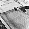
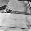
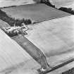
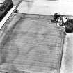
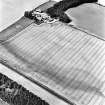
A linear cropmark (NT c.5490 1683 to NT c.5509 1683) has been revealed by oblique aerial photography (RCAHMSAP 1995) immediately to the E of Cavers Mains farmsteading. It is aligned WSW-ENE, curving sharply to the SE after about 130m, and it is visible for a total distance of at least 210m. It intersects the NE side of a Roman Temporary Camp (NT51NW 25).
Information from RCAHMS (KJ) 3 August 1999.
Watching Brief (28 August 2013)
NT 54857 16826 A watching brief was undertaken on 28 August 2013 during ground-breaking work associated with construction of an extension to the farmhouse at Cavers Mains. The removal of the topsoil from the development footprint exposed the concrete foundations of a small
rectangular structure associated with a 20th-century phase of the farmstead. A number of foundation trenches were excavated around the perimeter of the development footprint. A 1.5m wide cobble surface, thought to be associated with the 19th-century farmstead, was exposed in one of these trenches. No features predating the farmstead (c1850) were recorded during the watching brief.
Archive: RCAHMS
Funder: Mr J Sinclair on behalf of Albrighton Roses Ltd
Donald Wilson – Headland Archaeology Ltd
(Source: DES)
Sbc Note
Visibility: This site is visible as a cropmark.
Information from Scottish Borders Council

