
Scheduled Maintenance
Please be advised that this website will undergo scheduled maintenance on the following dates: •
Tuesday 3rd December 11:00-15:00
During these times, some services may be temporarily unavailable. We apologise for any inconvenience this may cause.
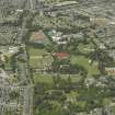
Aberdeen, Westburn, Westburn Park


Park (Period Unassigned)
Site Name Aberdeen, Westburn, Westburn Park
Classification Park (Period Unassigned)
Alternative Name(s) Gilcomston Burn; Westburn Road; Cornhill Road; Westburn Drive; Westburn House Policies
Canmore ID 148106
Site Number NJ90NW 678
NGR NJ 9263 0703
NGR Description Centred NJ 9263 0703
Datum OSGB36 - NGR
Permalink http://canmore.org.uk/site/148106

- Council Aberdeen, City Of
- Parish Aberdeen
- Former Region Grampian
- Former District City Of Aberdeen
- Former County Aberdeenshire
NJ90NW 678 centred 9263 0703
For (included) Westburn House and (former) hydropathic establishment within the area of the park, see NJ90NW 674 and NJ90NW 1720 respectively.
For Elmhill House (NJ 9272 0740 and associated lodge (NJ 9272 0740) within the area of the park, see NJ90NW 1726.00 and NJ90NW 1726.01 respectively.
Not to be confused with (adjacent) Victoria Park, for which see NJ90NW 662.
Westburn Park [NAT]
OS 1:1250 map, 1969.
Westburn Park opened to the public in 1901.
NMRS, MS/712/83.

