
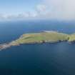
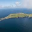
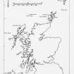
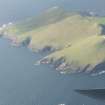
Rona


Kiln Barn (Post Medieval), Township (Post Medieval), Rotary Quern(S) (Post Medieval)
Site Name Rona
Classification Kiln Barn (Post Medieval), Township (Post Medieval), Rotary Quern(S) (Post Medieval)
Alternative Name(s) North Rona
Canmore ID 1479
Site Number HW83SW 8
NGR HW 809 322
NGR Description Centred HW 829 322
Datum OSGB36 - NGR
Permalink http://canmore.org.uk/site/1479


First 100 images shown. See the Collections panel (below) for a link to all digital images.
- Council Western Isles
- Parish Barvas
- Former Region Western Isles Islands Area
- Former District Western Isles
- Former County Ross And Cromarty
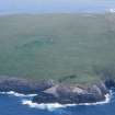
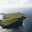
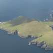
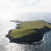
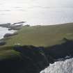
NORTH RONA (off Lewis)
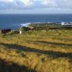
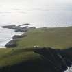
The site of one of the most complete Early Celtic religious complexes in Scotland, lying some 40 miles off the Butt of Lewis. St Ronan, Abbot of Kingarth in Bute (died 737), is said to have come here on the back of a whale to escape the noise of quarrelsome Lewis women. North Rona was abandoned after the Viking raids, but resettled by a secular community in the 12 th or 13 th century; when John Morison visited from Lewis in c.1680 it was 'inhabited & ordinarlie be five small tennants'. Disasters, such as the drowning of the island's entire male population, and starvation brought about by a plague of rats, resulted in only intermittent occupation during subsequent centuries; the last resident, Donald Macleod, left in 1844 . North Rona is now a National Nature Reserve with Sula Sgeir. Sited on a terrace within a thick-walled, oval burial enclosure,
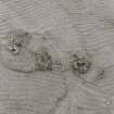
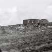
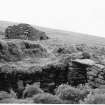
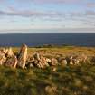
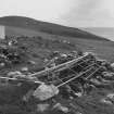
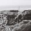
Teampall Rònain was probably a hermitage offshoot from the church at Europie in Lewis. It is two-chambered, the almost subterranean corbelled eastern cell being the late 7th/early 8th century 'oratory' of St. Ronan, beautifully constructed with inward-leaning walls bridged over with stone slabs, traces of lime mortar still clinging to the sides. On the west wall, a door with slit window above leads into the 12 th-century chapel, its west gable still standing to six or seven ft. A stone-paved doorway was uncovered by Dr. Frank Fraser Darling on the south wall during his repair works here in 1938. He also excavated the east end of the earlier structure, unearthing the base of a stone altar and wall niche. Numerous Early Christian and medieval incised cross slabs lie on the site.
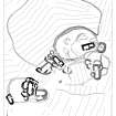
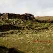
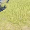
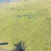
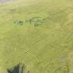
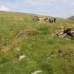
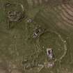
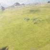
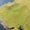
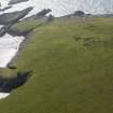
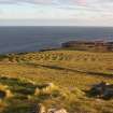
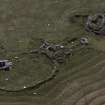
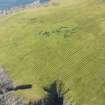
The 'village' to the south, dating from the medieval resettlement of North Rona, comprises three groups of sunken beehivelike dwellings, now a grass-grown honeycomb of stone walls and tunnels. One of these, the home of Kenneth MacCagie, was visited by John MacCulloch in 1819: 'The entrance to this subterranean retreat is through a long, dark, narrow and tortuous passage like the gallery of a mine, commencing with an aperture not three feet high and very difficult to find' he wrote, describing the outer appearance of the house as like 'a collection of turf stacks and dunghills'. An open field system is well preserved, with seams of narrow rigs enclosed by a dyke.
Taken from "Western Seaboard: An Illustrated Architectural Guide", by Mary Miers, 2008. Published by the Rutland Press http://www.rias.org.uk

HW83SW 8 centred 809 322
'A': HW 8092 3233
'B': HW 8088 3234
'C': HW 8085 3230
Rona Village - possibly Norse to late-Mediaeval village composed of three dwelling complexes each apparently originally consisting of a central, sub-rectangular structure, tentatively classed as a Birsay-type Viking house round which possibly 15th to 17th c. corbelled structures have accrued. The island was inhabited until 1683, these complexes presumably forming the dwellings. Periodic occupation since 1683 accounts for the probably 19th c primitive black-house in Group 'C' and the alleged 'Manse' - a 19th - 20thc building in Group 'B'.
Within the enclosing head dyke, but apart from the village, there is the ruin of a stone-built structure of unknown purpose. It is now badly tumbled but has apparently been square in plan with sides 10' to 12'long. It may have been divided internally at its lower end by a partition 3'to 4' long.
Also within the head-dyke are two wells which still carry water although one is now badly fouled and the other slightly salty. The arable land within the dyke has been cultivated into long sinuous ridges.
H C Nisbet and R A Bailey 1960.
Field Visit (14 July 1924)
Immediately west of the church are a number of primitive dwellings, including a central, oblong enclosure with rounded angles some 30 feet by 11 feet broad by 7 feet high, formed in drystone walling and evidently roofed with timber. On one side within the wall, which is in places 13 and 14 feet in thickness, is a low flagged passage or gallery 2 ¼ feet wide, while on the other side three smaller oval ‘beehive’ chambers are attached.
RCAHMS 1928, visited 14 July 1924
Ground Survey (1958)
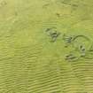
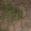
In summer 1958 a party from Glasgow University carried out a detailed ground survey of the ecclesiastical and domestic structures on North Rona. The village is situated towards the NW corner of an infield of about 20 acres, cultivated in large lazybeds. The pattern of domestic architecture is of a central rectangular courtyard about 30ft by 10ft, surrounded by a variable arrangement of low covered passages and small circular or oval corbelled cells. Two such steadings are built close against the outside of the chapel enclosure wall, on the S side; a third stands apart, a little to the south.
Saint Ronan’s cell and chapel stand in the SE corner of a roughly oval enclosure bounded by a heavy stone and turf wall. The small rectangular cell, almost certainly built before 900 AD, is well preserved, while the medieval chapel which was added to form a nave to it is of more elaborate design and inferior execution.
The houses were occupied as least as late as 1683, and all show signs of reconstruction. A lower limit for the date of human settlement has not been established.
H Nisbet, Discovery and Excavation in Scotland, 1958
Note (26 June 1997)
Nine unroofed buildings, four of which are annotated as Ruins and one is a Church [HW83SW 1], seven enclosures and a head-dyke are depicted on the 1st edition of the OS 6-inch map (Ross-shire, Island of Lewis 1854, sheet 47). One partially roofed, four unroofed buildings, three enclosures and a head-dyke are shown on the current edition of the OS 1:10000 map (1973).
Information from RCAHMS (SAH), 26 June 1997.
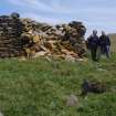
Measured Survey (5 July 2009)
Ian Parker (RCAHMS Surveyor) and Jill Harden surveyed this site on 5 July 2009 at a scale of 1:500 with plane-table and self-reducing alidade. The plan was drawn up in graphic vector software in 2013.
Excavation (June 2012)
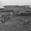
HW 8091 3231 (centred on) Two small trenches were excavated close to the main settlement area on North Rona in June 2012. The first 1m2 trench was on the W side of the enclosure around the Early Christian oratory. It was located against the external face of the enclosure to avoid any disturbance to the protected nesting Leach's Storm Petrels. The aim of the work was to retrieve material suitable for dating from beneath the foundations of the broad stone-revetted wall. A 0.7m deep deposit of soil was excavated and samples taken from the layer below the base of the wall. The second 2 x 3m trench was located 30m S of the enclosure, and spanned the boundary between an area of lazy beds (N) and an area where there were no obvious raised beds (S). Samples were taken from the 0.6m (N) and 0.4m (S) deep agricultural soils.
Archive: RCAHMS (intended)
Funder: Part grant-aided by the Hunter Archaeological Trust
Jill Harden, 2012
(Source: DES)
Photographic Record (5 June 2016)
Note (June 2017)
Rona of the Ocean
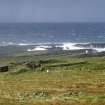
Sometime around 1680, the tacksman of St Kilda, his wife and a ‘good crew’ set sail back to the Outer Hebrides, carrying with them much of the St Kildan’s rent for that year as produce. A great storm blew up and the small boat was forced to turn before the wind. Past Harris and Lewis she flew, sea foaming along the gunnels, men straining sinew to hold her course before the ever strengthening waves. At last they were cast ashore on the island of Rona, an outpost even more distant than St Kilda itself, 130 miles to the northwest, and 45 miles from the nearest shore. True to the poetry of Gaelic, the island’s local name, Ronaidh an t’haf, means Rona of the Ocean.
The party of Macleods must have called out for help as they staggered up the steep slopes towards the huddle of five houses, but no reply came. They found a young woman dead in the first house, with a child at her breast. Each of the 30 or so people on the island had succumbed to starvation or disease, and the exhausted mariners were left to fend for themselves. For the months of winter the Macleods tarried, surviving on the produce of St Kilda (grain, cheese and tallow) and the peat stored for fuel, and patiently waiting for a spell of calm weather. Lucky enough to have a carpenter among them, and wood to salvage from the islanders houses, they eventually sailed into Stornoway to a feast and celebration that lasted ‘for some days’ (Robson 2001, 30). Rona was resettled after this disaster, but the population dwindled from five families to one shepherd and his flock, before it was abandoned as a permanent settlement around 1840.
It is a world apart, a fertile, green and uninhabited island amid a turbulent and ever-changing sea. On most days, the lookout offers nothing but ocean and the gannet rocks of Sula Sgeir to the west. But on a warm summer’s day, the hills of Lewis appear, and those of Sutherland and Orkney. For the archaeologist it offers an unparalleled opportunity to study the development of a unique Hebridean landscape. The settlement and houses, and the fields of hand-dug ‘lazy beds’ (feannagan), speak to a gradual decline from the 17th to the 19th centuries, but are rare in their good preservation, and the richness of the folklore and tradition that survives among the communities of Ness on Lewis. Outside the settlement, the landscape is dotted with peat stands (used to dry the islanders fuel), and old dykes which separated out areas of grazing, all mapped by RCAHMS and Jill Harden in 2010.
The Chapel
It is the chapel that has attracted most attention from antiquaries and visitors, with archaeological records made since the 1850s. Set in an oval burial ground marked out by a ancient turf and stone dyke, the small building has laid claim to being one of Scotland’s earliest ecclesiastical buildings (Miers 2008), since its closest architectural parallels were thought to lie in the early medieval stone chapels of southwest Ireland. Roofless and ruined, the main room of the chapel is accessed through a low doorway and measures only 4.3m by 2.7m. Excavations were undertaken here in the 1930s by the famous naturalist Frank Fraser Darling and now the chapel acts as an informal store for carved stone fragments that range from early medieval grave markers to post-medieval rotary querns. A tiny door (accessible only by crawling) leads from the chapel into a chancel or oratory described by the Commission’s architect G P H Watson in 1924 as ‘manifestly much older than the western division’. The walls of the chancel converge as they rise in a type of building known as corbelling. Though certainly repaired over the years, and far from safe in its present state, it is a unique structure.
This tiny yet complex building still invites argument, discussion, research and debate. A close analysis of the building by Mark Thacker in 2012 led to a challenge to the notion that the chancel is Early Medieval at all, and an alternate explanation was put forward that the whole structure represented a Norse bi-cameral church of 12th century date. Thacker put further emphasis on the use of lime mortar in the building, arguing that plaster finishes in this building, lying at is did at the edge of the Christian world, may have symbolic as well as functional importance.
But Rona’s interest goes well-beyond the building archaeology of this fascinating chapel. Excavations on the island by archaeologist Jill Harden, the first to modern standards, set out to understand whether settlement on the island pre-dated the evidence provided by the Early Medieval sculpture for a Christian foothold. A radiocarbon date of c.600 AD from a carbonised cereal grain recovered from underneath the graveyard enclosure seemed to suggest clearly that the island was occupied and farmed long before (Harden pers. comm.), and causes us to think again about the possibility that the medieval remains overlie a settlement mound that is more ancient.
Rona remains an incredibly difficult place to get to with no regular transport links, no facilities other than a small researcher’s bothy, no power or water, and sometimes fierce weather – but it presents an unparalleled opportunity for adventure. The experience of working and living there is both rewarding and evocative, always with the sound of the sea and far from anywhere else. But a 12 hour close-reefed sail back to Stornoway, in an ocean-going yacht beyond Macleod’s imagination, is certainly not something I would like to repeat. Little known, it is certainly a jewel in the crown of the medieval archaeology of northwest Scotland, and one where many of the questions remained unanswered. As I write, I can recall the island as its summer growth pushes through, nesting birds wheel and dive across the azure sky, and the small flock of sheep move over its ancient and provocative forms. As the poet Kathleen Jamie said, writing about Rona from personal experience, ‘we can imagine a past as sweet, as though bathed in a bronze light’.
Sources:
Fisher, I 2001 Early Medieval sculpture in the West Highlands and Islands. RCAHMS and the Society of Antiquaries of Scotland.
Harden, J 2013 ‘Barvas, North Rona, Excavation’. Discovery and Excavation in Scotland 2012, 184-5.
Harden, J 2014 ‘Results from two small trial trenches dug close to the settlement on North Rona in June 2012’. Unpublished data structure report.
Jamie, K 2012 Sightlines. Sort of Books.
Miers, M 2008 The Western Seaboard, an architectural guide. Rutland
Nisbet, H and Gailey, R A 1960 ‘A survey of the antiquities on North Rona’ Archaeological Journal 117, 88-115
RCAHMS 1928 Ninth report with inventory of monuments and constructions in the Outer Hebrides, Skye and the Small Isles, 3-4.
Robson, M 1991 Rona, a distant island. Stornoway: Acair
Thacker, M 2013 ‘Making lime at the edge of the world: a mortar archaeology at the medieval chapel of St Ronain’s, North Rona, Scotland.’ 3rd Historic Mortars Conference, Glasgow
George Geddes - Archaeology Project Manager

