
Lochrie


Pit(S) (Period Unassigned), Ring Ditch (Period Unassigned)
Site Name Lochrie
Classification Pit(S) (Period Unassigned), Ring Ditch (Period Unassigned)
Alternative Name(s) Milton Of Noth; Water Of Bogrie
Canmore ID 147552
Site Number NJ52NW 128
NGR NJ 509 283
Datum OSGB36 - NGR
Permalink http://canmore.org.uk/site/147552


- Council Aberdeenshire
- Parish Rhynie
- Former Region Grampian
- Former District Gordon
- Former County Aberdeenshire
NJ52NW 128 509 283
See also NJ52NW 127.
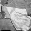
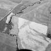
(Location cited as NJ 509 283 and name as Milton of Noth). Air photography (AAS/84/05/R10/9 and 13, flown 17 July 1984) has recorded the cropmark of a ring-ditch at an altitude of 170m OD.
NMRS, MS/712/52.

