
Pricing Change
New pricing for orders of material from this site will come into place shortly. Charges for supply of digital images, digitisation on demand, prints and licensing will be altered.
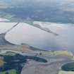
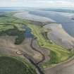
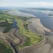
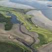
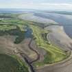
Ardwoan Pier


Pier (Period Unassigned)
Site Name Ardwoan Pier
Classification Pier (Period Unassigned)
Alternative Name(s) Ardvoan; Dornoch Firth
Canmore ID 14673
Site Number NH78NW 38
NGR NH 7383 8698
Datum OSGB36 - NGR
Permalink http://canmore.org.uk/site/14673


- Council Highland
- Parish Dornoch
- Former Region Highland
- Former District Sutherland
- Former County Sutherland
Field Visit (15 January 2014)
Remains of old pier consisting of stone boulders on landward side & remains of 8 wooden upright posts in intertidal area. c. 8 m wide & 26 m long with a possible further 10 metres into the water. Each side of the pier is formed by a stone wall with inner and outer faces in-filled with stone. In between the outside walls there are washed stones and pebbles.
Ardvoan was a quarter (0.4km) of a mile east of Meikle Ferry and was used as an emergency pier. It was a wooden structure used for the crossing of animals to Tain Friday market. Proc. Soc. Antiq Scot, 1987 vol.117 Page 228.
Visited by Scotland's Coastal Heritage at Risk (SCHARP) 2013

