
Burrow Head, Heavy Anti-aircraft Practice Battery And Domestic Site


Anti Aircraft Battery (20th Century), Building(S) (20th Century), Hut(S) (20th Century)
Site Name Burrow Head, Heavy Anti-aircraft Practice Battery And Domestic Site
Classification Anti Aircraft Battery (20th Century), Building(S) (20th Century), Hut(S) (20th Century)
Alternative Name(s) Ducker Rock; Burrow Head Holiday Farm
Canmore ID 146537
Site Number NX43SE 4
NGR NX 45106 34190
NGR Description Centred NX 45106 34190 and centred NX 4507 3444
Datum OSGB36 - NGR
Permalink http://canmore.org.uk/site/146537


- Council Dumfries And Galloway
- Parish Whithorn
- Former Region Dumfries And Galloway
- Former District Wigtown
- Former County Wigtownshire
NX43SE 4 4512 3422
Extends on to map sheet NX43SW
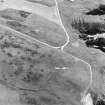
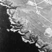
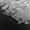
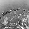
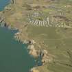
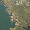
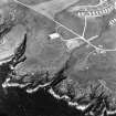
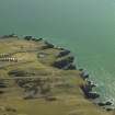
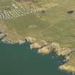
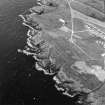
The remains of a heavy anti-aircraft practice battery are situated along the cliff-top to the W of Burrow Head, N of Ducker Rock. The brick and concrete remains consist of a series of gun holdfasts, command post and magazine with the the accommodation camp to the rear. Some of the area of the accommodation camp has been re-used by the Burrow Head Holiday Farm. A contemporary wartime photograph records at least five gun-emplacements with different calibre guns mounted.
J Guy 1999; NMRS MS 810/6, 213-214 (vol 1); 12-13 (vol 2).
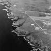
Examination of vertical air photographs of the anti-aircraft training battery (106G/Scot/UK 43, 4005-4007, flown 4 May 1946 and All Scotland Survey [Jasair], 25 88 261-262, flown 13 June 1988), show that one of the gun-emaplacements has been partly demolished and that most of the huts in the accommodation camp have been removed.
The total area taken by the training camp was about 38.74 hectares including Cutcloy farmsteading. The air photographs taken in 1946 (ibid) show that there were four gun-emplacements, two are circular with ready-use ammunition lockers and two are square (NX 45150 34190, NX 45107 34189, NX 45080 34180 and NX 45030 34170). The coverage from 1988 (ibid) shows that the most easterly emplacement has been partly demolished by the excavation of a small quarry, the other three would appear to survive.
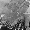
The accommodation camp consisted of at least 113 buildings, huts and Nissen huts. The 1988 air photographs show that most of the huts have been removed with permanent and mobile homes and caravans standing on the concrete bases of the some of the original huts, but many more concrete platforms are visible on the images.
Several original buildings are still in situ on the 1988 images, notably, what was possibly the magazine at NX 44916 34243 and buildings at NX 45322 34786 and NX 45069 34434, which appear to have been re-used by the Holiday Farm. What appear at NX 45395 34936 on the 1946 images to be water tanks, by the date of the 1988 images have been apprently replaced by large sheds.
Information from RCAHMS (DE), April 2006

