
Following the launch of trove.scot in February 2025 we are now planning the retiral of some of our webservices. Canmore will be switched off on 24th June 2025. Information about the closure can be found on the HES website: Retiral of HES web services | Historic Environment Scotland
Kinrive


Cairn(S) (Prehistoric)(Possible), Field System(S) (Prehistoric)(Possible), Hut Circle(S) (Prehistoric)
Site Name Kinrive
Classification Cairn(S) (Prehistoric)(Possible), Field System(S) (Prehistoric)(Possible), Hut Circle(S) (Prehistoric)
Canmore ID 14574
Site Number NH77NW 3
NGR NH 7050 7590
NGR Description Centred on NH 7050 7590
Datum OSGB36 - NGR
Permalink http://canmore.org.uk/site/14574


- Council Highland
- Parish Kilmuir Easter
- Former Region Highland
- Former District Ross And Cromarty
- Former County Ross And Cromarty
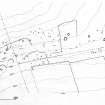
NH77NW 3 centred NH 705 759.
(A: NH 7020 7567; B: NH 7026 7567; C: NH 7043 7588; D: NH 7043 7591; E: NH 7052 7595; K: NH 7081 7597)
Hut Circle(s) (NR)
OS 25" map, (1969)
Centred at NH 705 759 on a SE-facing slope is a settlement of fourteen circular stone-walled huts (A - O) (twelve noted in 1899 (ISSFC 1902)), and a contemporary field system.
Where visible, the entrance to each hut is simple and in the E to SE arc. All hut diameters are given between the wall centres.
Hut 'A' is c.9.5m in diameter with the wall spread to c.2.0m all round. Outer facing stones on edge are visible in the N and SW arcs. The E arc is denuded and the entrance is not evident. A field wall skirts the NE arc.
'B' measures c.8.5m in diameter with a wall spread to c.2.0m all round. 'C', the best preserved, is c.15.0m in diameter, with the wall spread to c.2.5m at the rear, increasing gradually to c.4.0m at the entrance. The inner wall face is visible intermittently around the N arc, and the rubble of the wall core is exposed in several places.
'D' is c.9.5m in diameter with the wall spread to c.2.0m all round. Three outer facing stones are visible in the SE arc.
'E' is denuded and measures c.7.5m in diameter with the wall spread to
c.2.0m all round.
'F', on a knoll, is c.12.0m in diameter with the wall spread to c.2.5m all round. A boulder to the N of the entrance is in an outer facing stone.
'G' is c.10.0m in diameter with the wall spread to c.2.5m all round.
A track skirts the SW arc.
'H', on the NE side of a recent hill dyke, is c.9.0m in diameter with the wall spread to c.2.0m. The NW arc is scarcely discernible. The entrance is ill-defined.
'J' is c. 10.0m in diameter with the wall spread to c.2.5m widening to
c.3.5m at the S side of the entrance. The NW arc has been destroyed. Three outer facing stones on edge are visible in the N arc.
'K', set into the slope, is c.13.0m in diameter, with the wall spread to c.3.0m except at both sides of the entrance where it appears to increase to c.5.5m. This seems to be due to clearance piled against the hut, rather than to a clubbed entrance. The N arc is mutilated.
'L', set into the slope, is c.15.0m in diameter with the wall spread to c.2.5m all round. Lying against the inside of the wall some 4.0m W of the entrance is a pile of stones c.2.0m in diameter, possibly a clearance heap. A field wall terminates on a clearance heap which lies against the outside of the wall in the W.
'M', set into the slope, is c.14.5m in diameter with the wall spread to c.2.5m all round. The E arc and the entrance are mutilated.
'N', c.11.0m in diameter, is ill-defined by a wall spread to c.3.0m in the E where it is best preserved, and decreasing towards the NW where it is destroyed. A lynchet extends N from the N arc. The entrance is ill-defined.
'O' is c.12.5m in diameter with the mutilated wall destroyed in the E and spread to c.2.0m elsewhere. The entrance is not evident. A recent gap is in the S arc.
The field system is defined by stone clearance heaps (previously defined as tumuli (ISSFC 1902)), lynchets and field walls. Where best preserved on the slopes between the huts, whins mask details of cultivation plots, and elsewhere they are too indistinct to measure. Huts A and B and huts C and D occur within roughly sub-rectangular enclosures measuring respectively c.230.0m by c.70.0m and c.150.0m by c.90.0m, and there are traces of similar boundaries towards the E of the settlement, as if this is an area of adjacent homesteads rather than a settlement with communal cultivation, although there are clearance heaps outside these enclosures. The area to the E of hut 'O' is overlaid by a depopulated farmstead with contemporary cultivation.
ISSFC 1902; Visited by OS (N K B) 26 October 1970
Huts A - E and K - O surveyed at 1:2500.
Visited by OS (A A) 24 July 1973
Huts L - N surveyed at 1:10,000.
Visited by OS (J B) 17 July 1975
Some of the area is overlain by a later depopulated farmstead with contemporary cultivation. This site is primarily extant immediately outwith the south-eastern boundary of Kinrive Wood, and thus is not included within the SSSI. However there is no reason to suppose that it does not continue into the wood itself. Indeed the current series OS 1:10,000 map (1975) suggests this to be the case.
J Wordsworth, SSSIs, Scottish Natural Heritage, 1993.
Field Visit (November 1978)
Kinrive 1 NH 70 75, 70 76 NH77NW 3
There are four groups of monuments on the SE flank of Kinrive Hill. About 1.2km W of Torran farmhouse there is a rectangular enclosure (NH 702 756) measuring about 230m by 70m, which surrounds two hut-circles measuring about 9.5m and 8.5m respectively in diameter between wall-centres.
About 1 km WNW of Torran farmhouse there is a rectilinear enclosure (NH 704 758) measuring about 150m by 90m over a bank 1.5m thick and 0. 7m high, which surrounds two hut-circles measuring about 15m and about 8.5m respectively in diameter between wall-centres.
To the NE of the second rectilinear enclosure, and SW of a recent field-bank which crosses the hill from NW to SE, there are a number of small cairns, hut-circles and an enclosure.
To the E of the recent field-bank there are several hut-circles, two circular enclosures, several small cairns and some stretches of what are probably prehistoric enclosure-banks. Some of the enclosure-banks abut the hut-circles and circular enclosures.
RCAHMS 1979, visited November 1978
Measured Survey (1979)
The unenclosed settlement, field system and long cairns at Kinrive were surveyed at a scale of 1:1000.
Visited by RCAHMS (AL, SS) 1979

