
Pricing Change
New pricing for orders of material from this site will come into place shortly. Charges for supply of digital images, digitisation on demand, prints and licensing will be altered.
Upcoming Maintenance
Please be advised that this website will undergo scheduled maintenance on the following dates:
Thursday, 9 January: 11:00 AM - 3:00 PM
Thursday, 23 January: 11:00 AM - 3:00 PM
Thursday, 30 January: 11:00 AM - 3:00 PM
During these times, some functionality such as image purchasing may be temporarily unavailable. We apologise for any inconvenience this may cause.
Blackstand


Mound (Period Unassigned)
Site Name Blackstand
Classification Mound (Period Unassigned)
Canmore ID 14535
Site Number NH76SW 4
NGR NH 7187 6113
Datum OSGB36 - NGR
Permalink http://canmore.org.uk/site/14535


- Council Highland
- Parish Cromarty
- Former Region Highland
- Former District Ross And Cromarty
- Former County Ross And Cromarty
NH76SW 4 7187 6113.
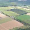
(NH 7187 6113) This is a long grass-covered mound with rounded ends, resembling a long cairn in some respects, but which Miss Henshall considers more likely to be natural than artificial.
It measures 264' long NE-SW, by 95' wide, and stands to an average height of 12' although the NE end is a little higher.
A A Woodham 1956; Information from A A Woodham to OS; A S Henshall 1963.
A large natural mound.
Visited by OS (N K B) 21 January 1966.

