
Pricing Change
New pricing for orders of material from this site will come into place shortly. Charges for supply of digital images, digitisation on demand, prints and licensing will be altered.
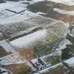
Grey Cairn, Glenurquhart


Cairn (Prehistoric)
Site Name Grey Cairn, Glenurquhart
Classification Cairn (Prehistoric)
Canmore ID 14533
Site Number NH76SW 2
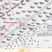
NGR NH 73386 62468
Datum OSGB36 - NGR
Permalink http://canmore.org.uk/site/14533


- Council Highland
- Parish Cromarty
- Former Region Highland
- Former District Ross And Cromarty
- Former County Ross And Cromarty
NH76SW 2 7338 6247.
(NH 7338 6247) Grey Cairn (NR)
OS 6" map, (1959)
Grey Cairn, prominently placed on a ridge, stands to a height of about 2.0m and measures about 20.0m NE-SW by about 18.0m transversely. There is a recent hollow in its NE arc. There is no evidence to support Woodham's suggestion that it is chambered. It stands on a stony platform about 0.3m high which is surrounded by a stony sub-circular bank about 2.0m wide retained externally by a kerb of stones on edge and measuring about 26.0m NE-SW by about 24.5m transversely overall. None of these stones seems large enough to be the kerb of the cairn itself and it appears that this platform and bank are original features, and not due to the robbing which has mutilated the cairn particularly on the NE. At the moment the cairn sits eccentrically within the bank and merges with it in the E, but this is probably due to the way the cairn has tumbled and partly to the robbing.
Re-surveyed at 1/2500.
Visited by OS (N K B) 21 January 1974 and (A A) 7 January 1971.
A A Woodham 1956.
No change to previous report.
Surveyed at 1:10 000.
Visited by OS (J M) 10 January 1978.
Scheduled with NH76SW 13.
Information from Historic Scotland, scheduling document dated May 1989.
Field Visit (24 August 1943)
Grey Cairn, Glenurquhart
Due W of Glenurquhart farm, on the very highest point of the wide ridge that, running NE, terminates in the South Sutor, stands a cairn of naked stones rising some 8ft above the heather-clad moor but itself surmounted by a trig. survey station. The cairn has clearly been disturbed but perhaps only superficially. No chamber or cist is exposed. The naked pile forms an irregular figure about 80ft NE to SW by 60ft, but the spread of stones, including some that look rather like peristalith supports, extends over a space some 95ft by 75ft among the deep heather.
65ft E of the Grey Cairn is a low stony mound* about 60ft long by 33ft wide N to S. The whole is overgrown with peat and heather and over 3ft high but is distinctly stony.
Visited by RCAHMS (VGC) 24 August 1943
*this is almost certainly a reference to NH76SW 13, which lies about 65 ft (20m) to the west (GG, 9/12/21).
Field Visit (July 1979)
Grey Cairn, Glenurquhart NH 733 624 NH76SW 2
This massive round cairn measures 20m in diameter and 2.5m in height. It is surmounted by a small modern cairn.
RCAHMS 1979, visited July 1979
(Woodham 1956, 74, No. 15)
Measured Survey (17 April 1980)
The cairn and long cairn at Glenurquhart were surveyed by plane-table at a scale of 1:250.
Visited by RCAHMS (JBS, AL, RM), 17 April 1980.

