
Mull, Tobermory River


Building (Period Unassigned), Corn Drying Kiln (Period Unassigned), Quarry (Period Unassigned), Track (Period Unassigned)
Site Name Mull, Tobermory River
Classification Building (Period Unassigned), Corn Drying Kiln (Period Unassigned), Quarry (Period Unassigned), Track (Period Unassigned)
Canmore ID 145307
Site Number NM45SE 21
NGR NM 4980 5427
Datum OSGB36 - NGR
Permalink http://canmore.org.uk/site/145307


- Council Argyll And Bute
- Parish Kilninian And Kilmore
- Former Region Strathclyde
- Former District Argyll And Bute
- Former County Argyll
NM45SE 21 4980 5427
One unroofed building is depicted on the 1st edition of the OS 6-inch map (Argyllshire, Island of Mull 1881, sheet xxxviii), but it is not shown on the current edition of the OS 1:10000 map (1976).
Information from RCAHMS (SAH) 4 June 1998.
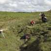
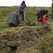
Field Visit (May 2009 - May 2009)
Measured survey by Scotland's Rural Past Mull groups. The survey took place as a parallel event to the Time Team excavation of the chapel at Coille Creag A'Chait (NM45SE 25) - a site which had been discovered by SRP Baliscate in 2008.
Srp Note (7 July 2011)
This dry-stone building is situated in rough grazing c200m NNW of the Baliscate standing stones (NM 45SE 1). It appears to have had two compartments and was aligned NW – SE along the line of a shallow slope, with an entrance in the NE wall of the E compartment. A track overlies and obscures its SE corner and most of its external S wall, and much of the N and W walls have been robbed out. On the SW side of the track, c 5m from the building, there is a corn drying kiln built into the slope, with its flue facing onto the track. The bowl measures 1.3m in diameter and the flue is 1.3m long.
The track leads to a small quarry c50m to the NW, at NM 49768 5430. En-route to the quarry, it cuts through a dry-stone dyke which lies c5m NW of the building. At this point, on the lower (NE) side of the track, a small open-ended structure with stone-faced turf walls has been built against the dyke. This structure may relate to the quarry, but the two-compartment building and the corn drying kiln clearly pre-date it.
The site was surveyed by Scotland's Rural Past Mull groups in May 2009, during the Time Team excavation of the chapel at Coille Creag A'Chait (NM45SE 25).
Information from SRP Baliscate, July 2011.

