
Quarterside Of Lipney


Field System(S) (Post Medieval), Head Dyke (Post Medieval), Rig And Furrow (Post Medieval)
Site Name Quarterside Of Lipney
Classification Field System(S) (Post Medieval), Head Dyke (Post Medieval), Rig And Furrow (Post Medieval)
Canmore ID 145094
Site Number NS89NW 83.03
NGR NS 8460 9813
NGR Description Centred on NS 8460 9813
Datum OSGB36 - NGR
Permalink http://canmore.org.uk/site/145094


- Council Stirling
- Parish Logie (Stirling)
- Former Region Central
- Former District Stirling
- Former County Stirlingshire
Field Visit (19 May 1997)
NS89NW 83.03 Centred on 8460 9813
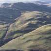
A field-system, head-dyke and rig lie across a broad, gently, sloping terrace between the edge of the gorge of the Menstrie Burn and the steeper ground on the E flank of Dumyat. The head-dyke runs up the hill from the edge of the gorge, on an axis from NE to SW, perhaps continuing to join the head-dyke to the W of a farm track along the valley side (NS 8440 9789). The head-dyke overlies several small plots, containing faint cultivation furrows, to the E of the N of two farmsteads (NS89NW 83.02) and also forms part of a later plot (NS 8457 9831). It is also overlain by a mound, possibly the remains of a turf hut (NS89NW 83.02).
The fragmentary remains of two field-systems lie to the NE and SE of the northern of two farmsteads (NS89NW 83.02). That to the SE comprises an oval field and an arc of bank ( NS 8460 9812) and is overlain by ridging. The plots to the NE of the farmstead (NS 8452 9824) are roughly rectilinear on plan and have been overlain by the head-dyke. The faint remains of rig within these plots are also overlain by the head-dyke.
The extent of the ridged ground is defined by the steeper slopes on the flank of Dumyat and the leading edge of the terrace beside the gorge where there is an intermittent lynchet. There is a broad correspondence between cultivated ground shown on an early 19th century estate plan (SRO, RHP 20943) and the areas of rigs, which measure between 3m and 5m between furrows. In places the rigs have been slighted by subsequent ploughing, perhaps for reseeding.
Visited by RCAHMS (DCC) 19 May 1997

