
Backside Of Lipney


Enclosure(S) (Post Medieval), Field System (Post Medieval), Head Dyke (Post Medieval), Rig And Furrow (Post Medieval)
Site Name Backside Of Lipney
Classification Enclosure(S) (Post Medieval), Field System (Post Medieval), Head Dyke (Post Medieval), Rig And Furrow (Post Medieval)
Alternative Name(s) Loss Burn
Canmore ID 145033
Site Number NS89NW 72.02
NGR NS 8360 9870
NGR Description Centred on NS 8360 9870
Datum OSGB36 - NGR
Permalink http://canmore.org.uk/site/145033

- Council Stirling
- Parish Logie (Stirling)
- Former Region Central
- Former District Stirling
- Former County Stirlingshire
Field Visit (21 May 1997)
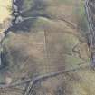
NS89NW 72.02 centred on 8360 9870
Fragmentary field banks enclose the ground sloping down to the Loss Burn to the NNE and E of the farmstead. A farm track runs along the upslope, S edge of these fields, which form part of a head-dyke that extends to the ESE, enclosing the lower ground on the S bank of the Loss and Menstrie Burns. This head-dyke is referred to in a tack of 1740 as the old head-dyke (Tack to Andrew Roy of Foreside and Quarterside: SRO, RH 15/115/1/2 bundle G).
Most of the ground within the large fields to the NNE and E of the farmstead has been ploughed for reseeding, obscuring earlier remains. However, curving, relatively widely spaced curving rig is visible on vertical aerial photographs (RAF 106G/SCOT/UK120, frame no. 3113, 20 June 1946) within the fields and roughly corresponding with patches of arable shown on an early 19th century Estate Plan (SRO RHP 20943). To the ESE of the larger fields there is a field-system composed of smaller plots which have been truncated on the WNW by more recent ploughing within the larger enclosures. The S side of the field-system composed of the smaller plots also forms part of the head-dyke described above, which extends along the track for a further 200m to the S. The steeper slopes at the foot of the valley on the S side of the Menstrie Burn are enclosed by earthen banks, several of which are stone faced on the upslope side. These may be late in the sequence of the enclosure and may be tree-plantation banks, related to the emparkation of Loss, with the stone faced banks designed to keep cattle out of the trees. There is one turf-banked rectangular enclosure within the plantation banks (NS 8438 9858).
Visited by RCAHMS (DCC) 21 May 1997

