 |
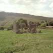
On-line Digital Images |
SC 579459 |
Records of the Royal Commission on the Ancient and Historical Monuments of Scotland (RCAHMS), Edinbu |
Scan of ground shot of Jerah. Scanned for Menstrie Glen publication. |
1998 |
Item Level |
|
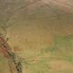 |
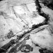
On-line Digital Images |
SC 579463 |
RCAHMS Aerial Photography |
Scan of aerial photograph D/24653/cn showing Jerah. Scanned for Menstrie Glen publication |
12/12/1997 |
Item Level |
|
 |
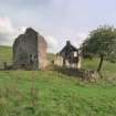
On-line Digital Images |
SC 584584 |
Records of the Royal Commission on the Ancient and Historical Monuments of Scotland (RCAHMS), Edinbu |
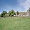
The shattered shell of the 19th century farmhouse at Jerah, seen from the north and looking to Dumyat beyond. |
1998 |
Item Level |
|
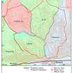 |
On-line Digital Images |
SC 1325580 |
Records of the Royal Commission on the Ancient and Historical Monuments of Scotland (RCAHMS), Edinbu |
Map showing property names in Menstrie Glen. Fig 9 in "Well shelterd & watered" Menstrie Glen, a farming landscape near Stirling. |
2001 |
Item Level |
|
 |
On-line Digital Images |
SC 1346654 |
Records of the Royal Commission on the Ancient and Historical Monuments of Scotland (RCAHMS), Edinbu |
Map showing distribution of settlements in Menstrie Glen before the 1760s with head-dykes and cultivated ground. Fig 11 in "Well shelterd & watered" Menstrie Glen, a farming landscape near Stirling. |
2001 |
Item Level |
|
 |
On-line Digital Images |
SC 1346655 |
Records of the Royal Commission on the Ancient and Historical Monuments of Scotland (RCAHMS), Edinbu |
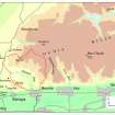
Map of the western end of the Ochils showing the location of Menstrie Glen. Fig 12 in "Well shelterd & watered" Menstrie Glen, a farming landscape near Stirling. |
2001 |
Item Level |
|
 |
On-line Digital Images |
SC 1346656 |
Records of the Royal Commission on the Ancient and Historical Monuments of Scotland (RCAHMS), Edinbu |
Map depicting arable land and settlement in the early 19th century. Fig 21 in "Well shelterd & watered" Menstrie Glen, a farming landscape near Stirling. |
2001 |
Item Level |
|
 |
On-line Digital Images |
SC 1346666 |
Records of the Royal Commission on the Ancient and Historical Monuments of Scotland (RCAHMS), Edinbu |
Illustration showing layout of farmsteads in the Menstrie Glen. Fig 31 in "Well shelterd & watered" Menstrie Glen, a farming landscape near Stirling. |
|
Item Level |
|
 |
On-line Digital Images |
SC 1346670 |
Records of the Royal Commission on the Ancient and Historical Monuments of Scotland (RCAHMS), Edinbu |
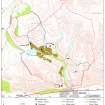
Details from OS 1st, 2nd and 3rd editions of Loss and Jerah farmsteads. Fig 35 in "Well shelterd & watered" Menstrie Glen, a farming landscape near Stirling. |
2001 |
Item Level |
|
 |
On-line Digital Images |
SC 1346671 |
Records of the Royal Commission on the Ancient and Historical Monuments of Scotland (RCAHMS), Edinbu |
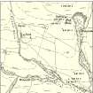
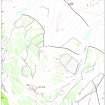
Map of Menstrie Glen showing locations of more detailed maps. Fig 39 in "Well shelterd & watered" Menstrie Glen, a farming landscape near Stirling. |
|
Item Level |
|
 |
On-line Digital Images |
SC 1346674 |
Records of the Royal Commission on the Ancient and Historical Monuments of Scotland (RCAHMS), Edinbu |
Map of Liittle Jerah farm. Fig 45 in "Well shelterd & watered" Menstrie Glen, a farming landscape near Stirling. |
2001 |
Item Level |
|
 |
On-line Digital Images |
SC 1346675 |
Records of the Royal Commission on the Ancient and Historical Monuments of Scotland (RCAHMS), Edinbu |
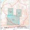
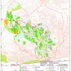
Map showing the extents of different types of rig in Menstrie Glen. Fig 48 in "Well shelterd & watered" Menstrie Glen, a farming landscape near Stirling. |
|
Item Level |
|
 |
On-line Digital Images |
SC 1346677 |
Records of the Royal Commission on the Ancient and Historical Monuments of Scotland (RCAHMS), Edinbu |
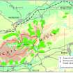
Extent of relict cultivation in the Ochil Hills. Fig 57 in "Well shelterd & watered" Menstrie Glen, a farming landscape near Stirling. |
|
Item Level |
|
 |
On-line Digital Images |
SC 1441189 |
Records of the Royal Commission on the Ancient and Historical Monuments of Scotland (RCAHMS), Edinbu |
View of farmhouse and out-building from south. |
1998 |
Item Level |
|
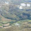 |
On-line Digital Images |
DP 222150 |
RCAHMS Aerial Photography Digital |
General oblique aerial view of Menstrie Glen centred on Backside of Lipney showing the recent afforestation, looking NE. |
19/9/2015 |
Item Level |
|
 |
On-line Digital Images |
DP 222151 |
RCAHMS Aerial Photography Digital |
General oblique aerial view of Menstrie Glen centred on Jerah Plantation showing the recent afforestation, looking NE. |
19/9/2015 |
Item Level |
|
 |
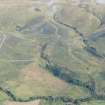
On-line Digital Images |
DP 222152 |
RCAHMS Aerial Photography Digital |
General oblique aerial view of Menstrie Glen centred on Jerah Plantation showing the recent afforestation, looking NE. |
19/9/2015 |
Item Level |
|
 |
On-line Digital Images |
DP 222153 |
RCAHMS Aerial Photography Digital |
General oblique aerial view of Menstrie Glen centred on Jerah Plantation showing the recent afforestation, looking NNE. |
19/9/2015 |
Item Level |
|
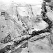 |
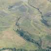
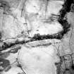
On-line Digital Images |
SC 1727238 |
RCAHMS Aerial Photography |
Oblique aerial view of Jerah centred on the remains of an archaeological landscape, taken from the NW. |
12/12/1997 |
Item Level |
|
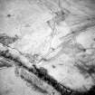 |
On-line Digital Images |
SC 1727239 |
RCAHMS Aerial Photography |
Oblique aerial view of Jerah centred on the remains of an archaeological landscape, taken from the WSW. |
12/12/1997 |
Item Level |
|
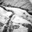 |
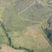
On-line Digital Images |
SC 1727240 |
RCAHMS Aerial Photography |
Oblique aerial view of Loss Burn centred on the remains of a farmstead, park and rig with an archaeological landscape adjacent, taken from the NNW. |
12/12/1997 |
Item Level |
|
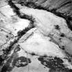 |
On-line Digital Images |
SC 1727241 |
RCAHMS Aerial Photography |
Oblique aerial view of Loss Burn centred on the remains of a farmstead, park and rig with an archaeological landscape adjacent, taken from the NW. |
12/12/1997 |
Item Level |
|
 |
On-line Digital Images |
SC 1727242 |
RCAHMS Aerial Photography |
Oblique aerial view of Loss Burn centred on the remains of a farmstead, park and rig with an archaeological landscape adjacent, taken from the NW. |
12/12/1997 |
Item Level |
|
 |
On-line Digital Images |
SC 1727243 |
RCAHMS Aerial Photography |
Oblique aerial view of Loss Burn centred on the remains of a farmstead, park and rig with an archaeological landscape adjacent, taken from the WNW. |
12/12/1997 |
Item Level |
|


