
Pricing Change
New pricing for orders of material from this site will come into place shortly. Charges for supply of digital images, digitisation on demand, prints and licensing will be altered.
Ashentrool


Enclosure(S) (Post Medieval), Field System(S) (Medieval) - (Post Medieval), Head Dyke (Post Medieval)(Possible), Rig And Furrow (Medieval) - (Post Medieval), Track(S) (Post Medieval)
Site Name Ashentrool
Classification Enclosure(S) (Post Medieval), Field System(S) (Medieval) - (Post Medieval), Head Dyke (Post Medieval)(Possible), Rig And Furrow (Medieval) - (Post Medieval), Track(S) (Post Medieval)
Canmore ID 144996
Site Number NS89NW 56.02
NGR NS 8300 9960
NGR Description Centred on NS 8300 9960
Datum OSGB36 - NGR
Permalink http://canmore.org.uk/site/144996


- Council Stirling
- Parish Logie (Stirling)
- Former Region Central
- Former District Stirling
- Former County Stirlingshire
Field Visit (5 June 1997)
NS89NW 56.02 centred on 8300 9960
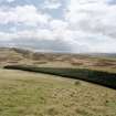
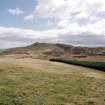
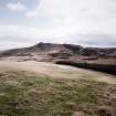
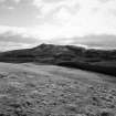
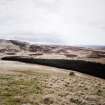
The S-facing flanks of Ashentrool and Loss Hill are covered by a palimpsest of enclosures and cultivation remains. A sequence can be detected in the cultivation remains which cannot be directly related to the settlements, except for the drystone wall which divides Ashentrool from Loss and overlies the earlier farmstead of Ashentrool (NS 89 NW 56.01).
On the lower ground broad, high-backed rig, measuring up to 12m between furrows and with a slight reverse-S on plan, is visible in a series of discrete blocks (NS 830 991; NS 823 994; NS 821 999). The eastern block of broad rig (NS 830 991) is overlain by a series of subrectangular fields containing rig characterised by shallow, closely spaced furrows, lying between 3m and 4m apart. These fields may also overlie a series of fields defined by roughly parallel banks to the W (NS 825 994). Most of the ridging across the rest of area is characterised by similar closely spaced shallow furrows.
Sequence elsewhere is more difficult to identify and tends to be localised. On a terrace between Ashentrool and Loss Hill, subrectangular fields, enclosed by a ring dyke, apparently overlie a bank, probably a head-dyke, which encloses much of Loss Hill and runs across on to Ashentrool Hill. There is evidence of enclosures overlain by ridging in at least two places (NS 8251 9957 and NS 8265 9945), whilst in other places enclosures, probably for stock, overlie rig (NS 8276 9967). One particular enclosure situated on the W flank of Loss Hill contains both ridged and uncultivated ground. Trackways, usually visible as hollows cutting across breaks of slope, appear to provide access to hill ground.
Visited by RCAHMS (DCC) 5 June 1997

