 |
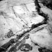
On-line Digital Images |
SC 1440979 |
Records of the Royal Commission on the Ancient and Historical Monuments of Scotland (RCAHMS), Edinbu |
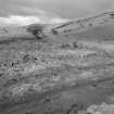
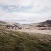
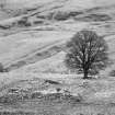
View of farmstead from east.
|
1998 |
Item Level |
|
 |
On-line Digital Images |
SC 1440980 |
Records of the Royal Commission on the Ancient and Historical Monuments of Scotland (RCAHMS), Edinbu |
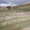
View of farmstead from east. |
1998 |
Item Level |
|
 |
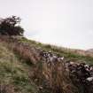
On-line Digital Images |
SC 1441190 |
Records of the Royal Commission on the Ancient and Historical Monuments of Scotland (RCAHMS), Edinbu |
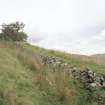
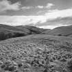
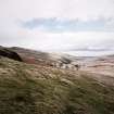
View of park dyke. |
1998 |
Item Level |
|
 |
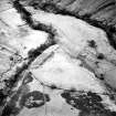
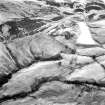
On-line Digital Images |
SC 1727240 |
RCAHMS Aerial Photography |
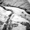
Oblique aerial view of Loss Burn centred on the remains of a farmstead, park and rig with an archaeological landscape adjacent, taken from the NNW. |
12/12/1997 |
Item Level |
|
 |
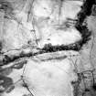
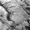
On-line Digital Images |
SC 1727241 |
RCAHMS Aerial Photography |
Oblique aerial view of Loss Burn centred on the remains of a farmstead, park and rig with an archaeological landscape adjacent, taken from the NW. |
12/12/1997 |
Item Level |
|
 |
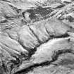
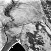
On-line Digital Images |
SC 1727242 |
RCAHMS Aerial Photography |
Oblique aerial view of Loss Burn centred on the remains of a farmstead, park and rig with an archaeological landscape adjacent, taken from the NW. |
12/12/1997 |
Item Level |
|
 |
On-line Digital Images |
SC 1727243 |
RCAHMS Aerial Photography |
Oblique aerial view of Loss Burn centred on the remains of a farmstead, park and rig with an archaeological landscape adjacent, taken from the WNW. |
12/12/1997 |
Item Level |
|
 |
On-line Digital Images |
SC 1727338 |
RCAHMS Aerial Photography |
Oblique aerial view. |
1982 |
Item Level |
|
 |
On-line Digital Images |
SC 1727339 |
RCAHMS Aerial Photography |
Oblique aerial view. |
1982 |
Item Level |
|
 |
On-line Digital Images |
SC 1727340 |
RCAHMS Aerial Photography |
Oblique aerial view. |
1982 |
Item Level |
|
 |
On-line Digital Images |
SC 1727341 |
RCAHMS Aerial Photography |
Oblique aerial view. |
1982 |
Item Level |
|
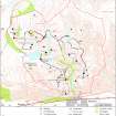 |
On-line Digital Images |
SC 2185384 |
Records of the Royal Commission on the Ancient and Historical Monuments of Scotland (RCAHMS), Edinbu |
Map showing distribution of settlements in Menstrie Glen before the 1760s. Fig 23 in "Well shelterd & watered" Menstrie Glen, a farming landscape near Stirling.showing property names in Menstrie Glen. Fig 12 in "Well shelterd & watered" Menstrie Glen, a farming landscape near Stirling. |
2001 |
Item Level |
|
 |
On-line Digital Images |
SC 2432859 |
Records of the Ordnance Survey, Southampton, Hampshire, England |
Loss Burn, NS89NW 40, Ordnance Survey index card, Recto |
c. 1958 |
Item Level |
|
 |
On-line Digital Images |
SC 2475531 |
Records of the Royal Commission on the Ancient and Historical Monuments of Scotland (RCAHMS), Edinbu |
View of park dyke. |
1998 |
Item Level |
|
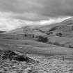 |
On-line Digital Images |
SC 2475545 |
Records of the Royal Commission on the Ancient and Historical Monuments of Scotland (RCAHMS), Edinbu |
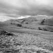
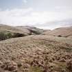
General view of Menstrie Glen from Backside of Lipney looking north-west across the glen. |
1998 |
Item Level |
|
 |
On-line Digital Images |
SC 2475546 |
Records of the Royal Commission on the Ancient and Historical Monuments of Scotland (RCAHMS), Edinbu |
General view of Menstrie Glen from Backside of Lipney looking north-west across the glen. |
1998 |
Item Level |
|
 |
On-line Digital Images |
SC 2475547 |
Records of the Royal Commission on the Ancient and Historical Monuments of Scotland (RCAHMS), Edinbu |
General view of Menstrie Glen from Backside of Lipney looking north-west across the glen. |
1998 |
Item Level |
|
 |
On-line Digital Images |
SC 2475548 |
Records of the Royal Commission on the Ancient and Historical Monuments of Scotland (RCAHMS), Edinbu |
General view of Menstrie Glen from Ashentrool (NS89NW 56.00) looking south-east. |
1998 |
Item Level |
|
 |
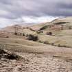
On-line Digital Images |
SC 2475552 |
Records of the Royal Commission on the Ancient and Historical Monuments of Scotland (RCAHMS), Edinbu |
View of Menstrie Glen from Ashentool |
1998 |
Item Level |
|
 |
On-line Digital Images |
SC 2475553 |
Records of the Royal Commission on the Ancient and Historical Monuments of Scotland (RCAHMS), Edinbu |
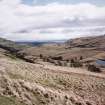
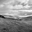
General view of Menstrie Glen from Loss. |
1998 |
Item Level |
|
 |
On-line Digital Images |
SC 2475554 |
Records of the Royal Commission on the Ancient and Historical Monuments of Scotland (RCAHMS), Edinbu |
General view of Menstrie Glen from Loss. |
1998 |
Item Level |
|
 |
On-line Digital Images |
SC 2475555 |
Records of the Royal Commission on the Ancient and Historical Monuments of Scotland (RCAHMS), Edinbu |
General view of Menstrie Glen from Ashentrool towards Loss. |
1998 |
Item Level |
|
 |
On-line Digital Images |
SC 2475556 |
Records of the Royal Commission on the Ancient and Historical Monuments of Scotland (RCAHMS), Edinbu |
General view of Menstrie Glen from Ashentrool towards Loss. |
1998 |
Item Level |
|
 |
On-line Digital Images |
SC 2475557 |
Records of the Royal Commission on the Ancient and Historical Monuments of Scotland (RCAHMS), Edinbu |
View of farmstead and country house from north. |
1998 |
Item Level |
|


