|
Photographs and Off-line Digital Images |
RC 5079 PO |
Papers of Professor John R Hume, economic and industrial historian, Glasgow, Scotland |
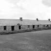
View looking North |
1974 |
Item Level |
|
 |
On-line Digital Images |
SC 435009 |
Papers of Professor John R Hume, economic and industrial historian, Glasgow, Scotland |
Balblair Cottages
View looking N |
1974 |
Item Level |
|
|
Manuscripts |
MS 726/167 |
Records of CFA Archaeology Ltd, archaeologists, Musselburgh, East Lothian, Scotland |
Coastal Assessment Survey: Inner Moray Firth, Volumes 1 and 2. |
14/12/1998 |
Item Level |
|
|
Manuscripts |
MS 1908 |
Stuart Farrell |
Report of archaeological desktop survey, Resolis Water Mains Renewal Project, on behalf of Scottish Water. |
3/2003 |
Item Level |
|
|
Manuscripts |
MS 1909 |
Stuart Farrell |
Copy of report, CD and plans for arcahaeological desktop and walkover survey, 20 & 21 March 2003, Stronlairig Hydro-electric scheme proposal. |
20/3/2003 |
Item Level |
|
|
Manuscripts |
MS 2776/1/6 |
Historic Scotland Archive Project |
Survey archive: Site record sheets, site record sheets with field notes and monument forms from the Inner Moray Firth (Moray, Beauly and Cromarty Firth) Coastal Assessment Survey. Sheet 6. |
9/1998 |
Item Level |
|
|
Prints and Drawings |
BD 104/1/6 |
Historic Scotland Archive Project |
Survey archive: 1:25,000 OS Pathfinder map depicting site locations from the Moray, Beauly and Cromarty Firth Coastal Assessment Survey. Sheet 6. |
9/1998 |
Item Level |
|
 |
On-line Digital Images |
SC 2366301 |
Records of the Ordnance Survey, Southampton, Hampshire, England |
Balblair, Cottages, Inverbreakie Pier, NH76NW 19, Ordnance Survey index card, Recto |
c. 1958 |
Item Level |
|
|
Photographs and Off-line Digital Images |
BS 97/6 CS |
Historic Scotland Archive Project |
Survey photographs: From the Moray, Beauly and Cromarty Firth Coastal Assessment Survey ¿ Jemimaville, Udale Bay, Newhall Point, Blablair, Ferryton Point Pier and Alnessferry. |
1998 |
Batch Level |
|


