
Following the launch of trove.scot in February 2025 we are now planning the retiral of some of our webservices. Canmore will be switched off on 24th June 2025. Information about the closure can be found on the HES website: Retiral of HES web services | Historic Environment Scotland
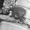
Preston Mill


Settlement (Period Unassigned)(Possible), Sunken Floored Building(S) (Period Unassigned)
Site Name Preston Mill
Classification Settlement (Period Unassigned)(Possible), Sunken Floored Building(S) (Period Unassigned)
Canmore ID 144920
Site Number NT57NE 104
NGR NT 59543 77940
Datum OSGB36 - NGR
Permalink http://canmore.org.uk/site/144920


- Council East Lothian
- Parish Prestonkirk
- Former Region Lothian
- Former District East Lothian
- Former County East Lothian
NT57NE 104 NT 59543 77940
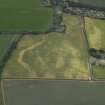
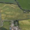
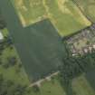
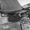
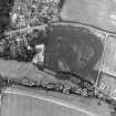
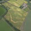
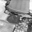
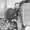
The cropmarks of a possible settlement have been revealed by oblique aerial photographs (RCAHMSAP 1995), immediately to the NE of Preston Mill (NT57NE 20). It may be sub-circular with an internal diameter of at least 100m. Three rectangular cropmarks are visible to the SE within the interior, measuring about 8m to 10m by 5m. A further rectangular mark is visible 30m to the NE. It measures about 20m WSW-ENE by 5m transversely.
Information from RCAHMS (KJ), 18 May 1999.

