
Pricing Change
New pricing for orders of material from this site will come into place shortly. Charges for supply of digital images, digitisation on demand, prints and licensing will be altered.
Cromarty, Burnside Place, The Brewery


Brewery (19th Century)
Site Name Cromarty, Burnside Place, The Brewery
Classification Brewery (19th Century)
Alternative Name(s) Cromarty, Old Brewery
Canmore ID 14475
Site Number NH76NE 50
NGR NH 79170 67282
Datum OSGB36 - NGR
Permalink http://canmore.org.uk/site/14475


- Council Highland
- Parish Cromarty
- Former Region Highland
- Former District Ross And Cromarty
- Former County Ross And Cromarty
NH76NE 50 79170 67282
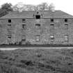
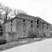
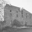
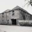
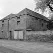
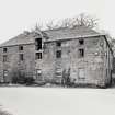
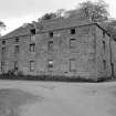
(Location cited as NH 791 673). Brewery, Cromarty, late 18th century. A rectangular 3-storey, 2- by 5-bay, red sandstone building, with a central hoist. Now empty.
J R Hume 1977.
NH76NE 50 79170 67282
Cromarty Brewery
Historical Background
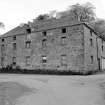
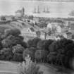
This brewery is situated close to a burn at the E extremity of Cromarty, on the corner of Miller Road and Burnside Place. A painting by I Clark in 1824 shows the building to have been laid out in an L-plan at that date, but its existing rectangular form dates at least from 1871 when it was recorded on the 1st edition Ordnance Survey map (Ross-shire, 1872, sheet LXVII). The brewery was established in about 1790 by George and Alexander Ross, who were the local landed proprietors. It was substantial in comparison with average Scottish rural breweries of the time, perhaps reflecting the fact that the Black Isle (and Easter Ross in general) were fine cereal growing areas. It is likely, therefore, that the port at Cromarty was used not only to export grain, but also beer.
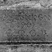
The OS map of 1871 shows the brewery to be disused, but whether it came back into use is not clear. A plaque above the door on the NW side of the buildings bears the inscription 'Thanks Be to God, 1901' and four illegible initials. It has been suggested that it was put there by a temperance society upon the closure of the brewery.
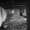
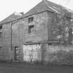
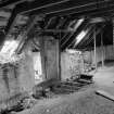
Since its closure, the brewery building has had a number of different uses. The NW bay was used prior to World War Two as a dwelling, and in the 1960s, the SW block was used to farm mushrooms on its middle and upper floors. Local sources suggest that the building has not been used since the 1940s, and is now in a state of advanced decay. It has lost all its internal brewery fittings and equipment, with the exception of possible kiln remains in the SW block.
General Description
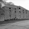
The building's rectangular form is comprised of two parallel ranges aligned NW-SE and connected by a narrow open space enclosed by screen-walls at each end, rising to the height of the wall heads. Overall, the plan dimensions are 18.0m (along the NE and SW sides) by 13.4m transversely. Each building is of three storeys and rises to the height of 5.75m at the wallhead. The walls are built form local red sandstone, and are of snecked rubble masonry with dressed quoins which bear raised margins. The walls are set on plinths and all window-openings have offset margins.
The roofs of the two blocks are hipped and covered with graded slate. The central ridges are capped with dressed stone ridge tiles but there are no tiles on the hipped ridges. There are snow-boards at the roof edges. There are also two cement-faced brick chimney stacks situated at the ends of the central ridge of the NE block.
Most windows on the upper floors were protected by side vertical wooden bars, each 0.03m square in section, and were also fitted with vertical two-leaf hinged shutters. In contrast, the ground floor windows of the NE block have wooden sash frames which probably relate to the period when part of the brewery was used as a dwelling. There is a high-level loading door at the centre of the upper floor on the NE facade of the building. This is furnished with an external wooden lifting beam which had a slot for a single pulley, which is protected by sheet metal.
Discontinuities in the NW and SW wall indicate substantial changes to this building but access to the interior of the building could not be obtained on the date of survey.
[Footnote: The Cromarty Firth area was embraced as a 'State Management District' under the Defence of the Realm Act in 1916. This related to areas in proximity to munitions manufacture and storage, and affected Cromarty because the Firth was used as a naval base, and experienced an influx of labourers and military personnel. Lloyd George's government was extremely worried at the idea of a combination of mass drunkenness and large stockpiles of high explosives. State control subsequently extended to all public houses and breweries in the area and although the brewery may have closed permanently at this time, it is possible that such interference may have played a part in its final closure].
Visited by RCAHMS (MKO, GJD) May 1986 (taken from NMRS Record sheet MS/232/HI/RO/3)
I Donnachie 1979; JR Hume 1977
NMRS MS/744/139

