
Fetlar, Hamara Field


Enclosure (Period Unknown)
Site Name Fetlar, Hamara Field
Classification Enclosure (Period Unknown)
Canmore ID 1447
Site Number HU69SW 25
NGR HU 60123 92823
Datum OSGB36 - NGR
Permalink http://canmore.org.uk/site/1447


- Council Shetland Islands
- Parish Fetlar
- Former Region Shetland Islands Area
- Former District Shetland
- Former County Shetland
HU69SW 25 6012 9281
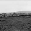
An enclosure or pund, formed of a series of large sepentine stones, lies on the summit of Hamara Field about 200yds NW of HU69SW 17 (a cist at HU 6004 9265)
Generally the stones are set singly edge to edge (the tallest measuring 3'6" high by 4'3" and 13" thick), but at the west corner, the setting seems to have assumed the character of a distinct wall, 3'4" thick, still traceable by the foundation courses. The SW side is particularly well-built. Stone 'B' in front of it does not seem to be displaced from the setting, but the significance of its position is uncertain. The opening 'A' in the NE may have been the entrance. The surface of the enclosure is level and does not differ in appearance from the ground outside, but near the centre are three large earth-fast stones as well as two which are loose.
RCAHMS 1946, visited 1934.
An enclosure of slabs set on edge as described and planned by the RCAHM at HU 6011 9283.
Date indeterminate.
Surveyed at 1/2500
Visited by OS (NKB), 18 May 1969.
Field Visit (11 July 1934)
Enclosure, Hamara Field. On the summit of Hamara Field, and about 200 yds. N.W. of the cairn (HU69SW 17), a series of large serpentine stones has been so arranged as to form an enclosure or "pund," roughly semicircular in plan (SC 1224311). The major axis, which lies N.W. and S.E., is 93 ft. long, while the minor one ranges from 37 ft. 6 in. to 48 ft. For the most part the stones are set singly, edge to edge, the tallest one rising 3 ft. 6 in. above the ground with a breadth of 4 ft. 3 in. and a thickness of 13 in. At the W. corner, however, the setting of stones seems to have assumed the character of a distinct wall, 3 ft. 4 in thick, still traceable by its foundation courses. The S.W. side, which is slightly concave for the greater part of its length, is particularly well built, the stones being always close together, whereas elsewhere gaps occur at irregular intervals, perhaps as the result of dilapidation. Near the middle of the concave portion a stone (B), as large as 5 ft. by 2 ft. 6 in. by about 1 ft., has been laid flat immediately in front. It does not seem to be a displaced member of the series; whether it has any special significance in its present position is uncertain. An opening (A) in the arc, towards the N.E., may have been the entrance. The surface of the enclosure is level and does not differ in appearance from the ground outside, but near the centre are three large earth-fast stones as well as two which are loose.
RCAHMS 1946, visited 11 July 1934.
Measured Survey (1934)
RCAHMS surveyed the enclosure at Hamara Field in 1934 by plane-table and alidade. The resultant plan and section were redrawn in ink and published at a reduced scale (RCAHMS 1946, fig. 545).

