
Pricing Change
New pricing for orders of material from this site will come into place shortly. Charges for supply of digital images, digitisation on demand, prints and licensing will be altered.
Harcarse Hill


Plantation Bank (Post Medieval)
Site Name Harcarse Hill
Classification Plantation Bank (Post Medieval)
Alternative Name(s) Harcarsehill
Canmore ID 144574
Site Number NT84NW 22
NGR NT 8125 4817
Datum OSGB36 - NGR
Permalink http://canmore.org.uk/site/144574


- Council Scottish Borders, The
- Parish Swinton
- Former Region Borders
- Former District Berwickshire
- Former County Berwickshire
Note (7 May 1999)
NT84NW 22 8125 4817
Vertical air photography (after removal of woodland): OS 71/050/237-8.
Information from RCAHMS (RJCM), 7 May 1999.
Field Visit (31 October 2014)
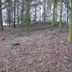
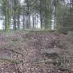
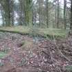
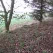
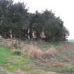
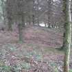
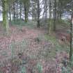
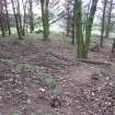
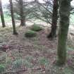
Within the modern stand of conifers on the summit of Harcarse Hill (83m OD) there are the remains of a plantation bank which encloses an area roughly 35m in diameter and is delimited by an earthen bank up to 1m high along its outer edge. The interior is pock-marked with tree-throws from earlier phases of planting, and supplemented by a modern water tank. There is no evidence of a cairn.
The plantation bank is depicted on the 1st edition of the OS 25-inch map (Berwick, 1862, Sheet XXII.8 (Swinton)).
Visited by RCAHMS (GFG) 31 October 2014.

