
Curriestanes


Cropmark(S) (Period Unknown)
Site Name Curriestanes
Classification Cropmark(S) (Period Unknown)
Canmore ID 144494
Site Number NX97NE 170
NGR NX 95905 75315
Datum OSGB36 - NGR
Permalink http://canmore.org.uk/site/144494


- Council Dumfries And Galloway
- Parish Troqueer (Dumfries-shire)
- Former Region Dumfries And Galloway
- Former District Nithsdale
- Former County Dumfries-shire
Aerial Photographic Transcription (31 May 2012)
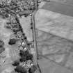
This possible palisaded enclosure has been recorded as a cropmark on oblique aerial photographs (RCAHMSAP 1992). It is defined by a section of a curved ditch about 0.6m wide. There are four cropmarks of indeterminate origin close by.
Information from RCAHMS (KHJM) 31 May 2012

