
Pricing Change
New pricing for orders of material from this site will come into place shortly. Charges for supply of digital images, digitisation on demand, prints and licensing will be altered.
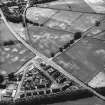
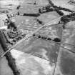
Kilncroft


Cropmark(S) (Period Unknown), Enclosure(S) (Period Unassigned)(Possible), Field Boundary(S) (Period Unassigned), Pit(S) (Period Unassigned)
Site Name Kilncroft
Classification Cropmark(S) (Period Unknown), Enclosure(S) (Period Unassigned)(Possible), Field Boundary(S) (Period Unassigned), Pit(S) (Period Unassigned)
Canmore ID 144485
Site Number NX97NE 169
NGR NX 95080 79600
NGR Description NX centred on 95080 79600
Datum OSGB36 - NGR
Permalink http://canmore.org.uk/site/144485


- Council Dumfries And Galloway
- Parish Holywood
- Former Region Dumfries And Galloway
- Former District Nithsdale
- Former County Dumfries-shire
NX97NE 169 centred on 95080 79600
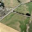
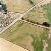
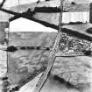
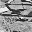
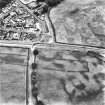
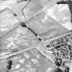
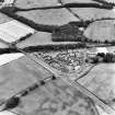
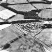
Aerial photography (RCAHMSAP 1995) has revealed a series of cropmarks in a field immediately to the W of Kilncroft farmsteading. An arc of large pits (NX 95260 79650) lies 10m E of three parallel linear cropmarks of varying width, running NNE-SSW for about 35m. The most westerly of these may form part of an enclosure, and two sides of a second possible enclosure are visible at NX c.9508 7965. A pair of closely spaced parallel linear cropmarks run across the NW corner of the field, and various indeterminate cropmarkings and pits are scattered across the field.
Information from RCAHMS (KB) 6 May 1999
Aerial Photographic Transcription (15 March 2003 - 28 March 2003)

