
Second Inchna Burn


Cultivation Terrace(S) (Medieval), Enclosure(S) (Medieval) - (Post Medieval), Field System(S) (Medieval) - (Post Medieval), Rig And Furrow (Medieval) - (Post Medieval)
Site Name Second Inchna Burn
Classification Cultivation Terrace(S) (Medieval), Enclosure(S) (Medieval) - (Post Medieval), Field System(S) (Medieval) - (Post Medieval), Rig And Furrow (Medieval) - (Post Medieval)
Canmore ID 144315
Site Number NS89NE 56.03
NGR NS 8510 9860
NGR Description Centred on NS 8510 9860
Datum OSGB36 - NGR
Permalink http://canmore.org.uk/site/144315


- Council Clackmannan
- Parish Alva
- Former Region Central
- Former District Clackmannan
- Former County Clackmannanshire
(NS 8493 9859) One enclosure of two unequal compartments is depicted on the 1st edition of the OS 6-inch map (Perthshire and Clackmannanshire 1865-6, sheet cxxxiii) and on the current edition of the OS 1:10000 map (1979).
Information from RCAHMS (SAH) 27 July 1999
Field Visit (24 April 1997 - 6 June 1997)
NS89NE 56.03 centred on 8510 9860
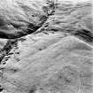
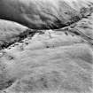
The ridge between the First and Second Inchna Burns has been extensively cultivated and enclosed. The principle element of the enclosure is a head-dyke, of at least two distinct phases which rides over the crest of the ridge. The first phase of enclosure runs approximately from N to S between the burns, while a secondary intake extends to the NE along the side of the Second Inchna Burn. A series of smaller plots have been laid out to the W of the head-dyke, generally enclosing about half a hectare each. A trackway, flanked by two banks runs through the plots, providing access to grazing beyond the head-dyke. Several of the plots built directly against the head-dyke do not appear to have been cultivated and may have been used for grazing. The majority of the cultivation, in the form of slightly curving furrows, some 2m to 3m apart and with a tendency to nip together towards the ends, is unenclosed and lies on the lower reaches of the ridge, downslope from the plots. Two blocks of rig along the SE bank of the Second Inchna Burn are characterised by the same slightly curving furrows, but spaced some 4m to 5m apart. The narrower rig appears to be a subdivision of the broader and may represent early attempts at improvement in the most intensively used part of the cultivated ground. Substantial lynchets have built up in places along the break of slope at the top of the steep valley sides. Along the N bank of the First Inchna Burn there are about a dozen terraces, aligned along the contour, which appear to predate the rig. Most serve to accentuate natural breaks in the hillside, but all have to some extent been levelled into the slope creating a terrace at least 4m to 5m across and extending up to 100m in length.
Visited by RCAHMS (DCC) 24 April and 6 June 1997

