|
Manuscripts |
MS 731/19 |
Records of the Royal Commission on the Ancient and Historical Monuments of Scotland (RCAHMS), Edinbu |
Afforestable Land Survey field database (Menstrie Glen survey, 1997). Held as attribute table in GIS and in Oracle Field/AP table. Please see DX001444 |
1997 |
Item Level |
|
|
Photographs and Off-line Digital Images |
D 20754 |
RCAHMS Aerial Photography |
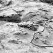
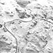
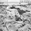
Oblique aerial view of Myreton Hill centred on the remains of a dun, hut, pen and field clearance cairns with a hut, enclosure and building adjacent, taken from the ENE. |
12/12/1997 |
Item Level |
|
|
Photographs and Off-line Digital Images |
D 20755 |
RCAHMS Aerial Photography |
Oblique aerial view of Myreton Hill centred on the remains of a dun, hut, pen and field clearance cairns with a hut, enclosure and building adjacent, taken from the NE. |
12/12/1997 |
Item Level |
|
|
Photographs and Off-line Digital Images |
D 20756 |
RCAHMS Aerial Photography |
Oblique aerial view of Myreton Hill centred on the remains of a dun, hut, pen and field clearance cairns with a hut, enclosure and building adjacent, taken from the NNE. |
12/12/1997 |
Item Level |
|
|
Photographs and Off-line Digital Images |
D 20757 |
RCAHMS Aerial Photography |
Oblique aerial view of Myreton Hill centred on the remains of a dun, hut, pen and field clearance cairns with a hut, enclosure and building adjacent, taken from the N. |
12/12/1997 |
Item Level |
|
|
Photographs and Off-line Digital Images |
D 24665 CN |
RCAHMS Aerial Photography |
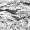
Oblique aerial view of Myreton Hill centred on the remains of a building, enclosure and possible hut with a building, farmstead, field-system, trackway and enclosures adjacent, taken from the W. |
12/12/1997 |
Item Level |
|
|
Photographs and Off-line Digital Images |
D 24666 CN |
RCAHMS Aerial Photography |
Oblique aerial view of Myreton Hill centred on the remains of a building, enclosure and possible hut with a building, farmstead, field-system, trackway and enclosures adjacent, taken from the NNE. |
12/12/1997 |
Item Level |
|
 |
On-line Digital Images |
SC 1346656 |
Records of the Royal Commission on the Ancient and Historical Monuments of Scotland (RCAHMS), Edinbu |
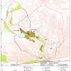
Map depicting arable land and settlement in the early 19th century. Fig 21 in "Well shelterd & watered" Menstrie Glen, a farming landscape near Stirling. |
2001 |
Item Level |
|
 |
On-line Digital Images |
SC 1726660 |
RCAHMS Aerial Photography |
Oblique aerial view of Myreton Hill centred on the remains of a dun, hut, pen and field clearance cairns with a hut, enclosure and building adjacent, taken from the ENE. |
12/12/1997 |
Item Level |
|
 |
On-line Digital Images |
SC 1726661 |
RCAHMS Aerial Photography |
Oblique aerial view of Myreton Hill centred on the remains of a dun, hut, pen and field clearance cairns with a hut, enclosure and building adjacent, taken from the NE. |
12/12/1997 |
Item Level |
|
 |
On-line Digital Images |
SC 1726662 |
RCAHMS Aerial Photography |
Oblique aerial view of Myreton Hill centred on the remains of a dun, hut, pen and field clearance cairns with a hut, enclosure and building adjacent, taken from the NNE. |
12/12/1997 |
Item Level |
|
 |
On-line Digital Images |
SC 1726663 |
RCAHMS Aerial Photography |
Oblique aerial view of Myreton Hill centred on the remains of a dun, hut, pen and field clearance cairns with a hut, enclosure and building adjacent, taken from the N. |
12/12/1997 |
Item Level |
|
 |
On-line Digital Images |
SC 1726671 |
RCAHMS Aerial Photography |
Oblique aerial view of Myreton Hill centred on the remains of a building, enclosure and possible hut with a building, farmstead, field-system, trackway and enclosures adjacent, taken from the W. |
12/12/1997 |
Item Level |
|
 |
On-line Digital Images |
SC 1726672 |
RCAHMS Aerial Photography |
Oblique aerial view of Myreton Hill centred on the remains of a building, enclosure and possible hut with a building, farmstead, field-system, trackway and enclosures adjacent, taken from the NNE. |
12/12/1997 |
Item Level |
|
|
Digital Files (Non-image) |
DX 001444 |
Records of the Royal Commission on the Ancient and Historical Monuments of Scotland (RCAHMS), Edinbu |
RCAHMS Structures Database - Menstrie Glen |
1997 |
Item Level |
|
|
Digital Files (Non-image) |
TM 000560 |
Records of the Royal Commission on the Ancient and Historical Monuments of Scotland (RCAHMS), Edinbu |
Zip file containing all survey linework collected during the RCAHMS Afforestable Land Survey of Menstrie Glen survey (1997). |
1997 |
Item Level |
|
|
Digital Files (Non-image) |
TM 002196 |
Records of the Royal Commission on the Ancient and Historical Monuments of Scotland (RCAHMS), Edinbu |
Zip file containing all survey linework collected during the RCAHMS Afforestable Land Survey of Menstrie Glen survey (1997). SHP and Geojson file formats with extra attribution added to the linework. |
1997 |
Item Level |
|


