
Pricing Change
New pricing for orders of material from this site will come into place shortly. Charges for supply of digital images, digitisation on demand, prints and licensing will be altered.
Craigmill


Pit Circle(S) (Prehistoric)(Possible), Rig And Furrow (Medieval) - (Post Medieval)
Site Name Craigmill
Classification Pit Circle(S) (Prehistoric)(Possible), Rig And Furrow (Medieval) - (Post Medieval)
Canmore ID 144297
Site Number NO53NE 79
NGR NO 5832 3631
Datum OSGB36 - NGR
Permalink http://canmore.org.uk/site/144297


- Council Angus
- Parish Panbride
- Former Region Tayside
- Former District Angus
- Former County Angus
NO53NE 79 5832 3631
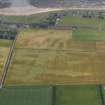
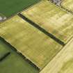
Oblique aerial photographs (RCAHMSAP 1995) have revealed a series of cropmarks in a field, 550m NE of Craigmill farmsteading. These include two possible pit-circles, one (NO c.5832 3231) measuring 6m in diameter, the other pit-circle (NO c.5828 3647) measuring about 15m in diameter. Cropmarks of rig-and-furrow cultivation, aligned NE-SW, are visible across the field (see also NO53NE 34).
Information from RCAHMS (KJ) 29 April 1999.

