
Margbeg


Farmstead (Period Unassigned)
Site Name Margbeg
Classification Farmstead (Period Unassigned)
Canmore ID 144214
Site Number NN63NE 80
NGR NN 6786 3612
Datum OSGB36 - NGR
Permalink http://canmore.org.uk/site/144214


- Council Stirling
- Parish Kenmore (Stirling)
- Former Region Central
- Former District Stirling
- Former County Perthshire
NN63NE 80 6786 3612
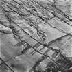
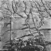
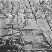
A farmstead, comprising two roofed buildings, two enclosures, and two roofed outbuildings, is depicted on the 1st edition of the OS 6-inch map (Perthshire 1867, sheet lxix).
Five unroofed buildings and an enclosure are shown on the current edition of the OS 1:10000 map (1981).
Recent aerial photography (RCAHMSAP 1995) has recorded this farmstead.
Information from RCAHMS (KB), 5 May 1999.

