
Pricing Change
New pricing for orders of material from this site will come into place shortly. Charges for supply of digital images, digitisation on demand, prints and licensing will be altered.
Upcoming Maintenance
Please be advised that this website will undergo scheduled maintenance on the following dates:
Thursday, 9 January: 11:00 AM - 3:00 PM
Thursday, 23 January: 11:00 AM - 3:00 PM
Thursday, 30 January: 11:00 AM - 3:00 PM
During these times, some functionality such as image purchasing may be temporarily unavailable. We apologise for any inconvenience this may cause.
Bandoch


Cropmark(S) (Period Unknown), Roundhouse (Prehistoric)
Site Name Bandoch
Classification Cropmark(S) (Period Unknown), Roundhouse (Prehistoric)
Alternative Name(s) Kirkton Mill
Canmore ID 144207
Site Number NO64NW 109
NGR NO 6488 4929
Datum OSGB36 - NGR
Permalink http://canmore.org.uk/site/144207


- Council Angus
- Parish Inverkeilor
- Former Region Tayside
- Former District Angus
- Former County Angus
NO64NW 109 6488 4929
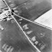
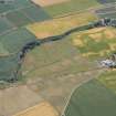
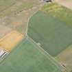
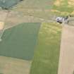
Bandoch. Round house; cropmarks
(Undated) information in NMRS.
Oblique aerial photographs (RCAHMSAP 1995) show the cropmarks of a round house, 100m NE of Bandoch farmsteading. This house, shown as a sub-circular marking, has the appearance and similarity to the houses excavated at Easter Kinnear (NO42SW 59), with its half round, half rectangular shape. Various other cropmarks are scattered around the area.
Information from RCAHMS (KJ) 28 April 1999.

