
Pricing Change
New pricing for orders of material from this site will come into place shortly. Charges for supply of digital images, digitisation on demand, prints and licensing will be altered.
Ballourie


Enclosure(S) (Post Medieval), Township (Post Medieval)
Site Name Ballourie
Classification Enclosure(S) (Post Medieval), Township (Post Medieval)
Canmore ID 144201
Site Number NH80NW 47
NGR NH 83075 06887
Datum OSGB36 - NGR
Permalink http://canmore.org.uk/site/144201


- Council Highland
- Parish Alvie
- Former Region Highland
- Former District Badenoch And Strathspey
- Former County Inverness-shire
NH80NW 47 830 069.
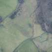
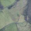
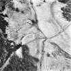
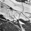
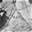
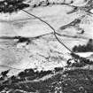
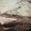
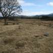
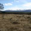
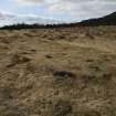
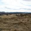
Aerial photography (RCAHMSAP 1995) has recorded the remains of a township and enclosures at the foot of a hillside 500m NE of Kincraig Farm. These structures are not depicted on the 1st edition of the OS 6-inch map (Inverness-shire 1874, sheets lxxiii) but are recorded as four unroofed buildings and a central enclosure on the current edition of the OS 1:10000 map (1995). At least one further unroofed building, and a possible circular enclosure at NH 8311 0698, are visible on the air photographs. A series of farmsteads, buildings, field banks and an area of rig and furrow cultivation have been recorded immediately to the E and S (NH80NW 13 and NH80NW 43 ).
Information from RCAHMS (KB) 5 May 1999
Field Visit (April 2013)
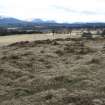
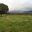
The remains of a township and enclosures, previously identified from aerial photography, were recorded during field survey in April 2013 as part of the Cairngorms Communities Heritage Partnership. They comprise the grass-grown footings of seven buildings and an enclosure to the S of a small burn at the foot of An Suidhe and some 500m NE of Kincraig Farm. To the N of the burn there are a further two buildings and two enclosures.
Information from HES Archaeological Survey (A.McCaig) 14 October 2024

