
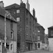
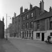
Bo'ness, 29 Waggon Road, Warehouse


Grain Warehouse (19th Century), Shop(S) (19th Century), Tenement (19th Century)
Site Name Bo'ness, 29 Waggon Road, Warehouse
Classification Grain Warehouse (19th Century), Shop(S) (19th Century), Tenement (19th Century)
Alternative Name(s) 9, 11, 13 North Street
Canmore ID 143862
Site Number NS98SE 89
NGR NS 99751 81653
Datum OSGB36 - NGR
Permalink http://canmore.org.uk/site/143862


- Council Falkirk
- Parish Bo'ness And Carriden
- Former Region Central
- Former District Falkirk
- Former County West Lothian
Characterisation
This site falls within the Bo'ness Town Centre Area of Townscape Character (NS98SE 201), which was defined as part of the RCAHMS Urban Survey Programme 2013. Text relating to the historical development and topography, and present character of the Bo'ness Town Centre Area of Townscape Character can be viewed at site NS98SE 201.
Information from RCAHMS (LK), January 2014

