
Corbie Knowe


Anti Tank Blocks (20th Century)
Site Name Corbie Knowe
Classification Anti Tank Blocks (20th Century)
Canmore ID 143854
Site Number NO64NE 73
NGR NO 6926 4887
Datum OSGB36 - NGR
Permalink http://canmore.org.uk/site/143854


- Council Angus
- Parish Inverkeilor
- Former Region Tayside
- Former District Angus
- Former County Angus
NO64NE 73 6926 4887
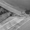
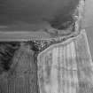
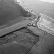
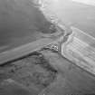
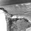
Oblique aerial photographs (RCAHMSAP 1995) show two areas of anti-tank blocks (at NO 6926 4887 and NO 6929 4881), situated on the high water point on the shoreline at Bird's Knap, Lunan Bay. The anti-tank blocks are also visible on WW II vertical aerial photographs (RAF 772.H21.140 6.63, flown 1942).
Information from RCAHMS (KJ) 20 April 1999.
A line of concrete anti-tank blocks along the beach E of Corbie Knowe.
J Guy 2000; NMRS MS 810/9
Three lengths of anti-tank blocks are visible around Corbie Knowe on RAF WW II and postwar vertical air photographs (D309, 5025-5026, flown 26 June 1941 and 106G/Scot/UK 128, Pt.III, 6231-6232, flown 25 June 1946 respectively.
The length noted by Guy (J Guy 2000) and RCAHMS (1999), ran N-S along the beach at high water mark, whilst the two other lengths, one running diagonally across the Keilor Burn and the road from Inverkeilor at a point just above the beach (c.NO 6929 4879), with another short v-shaped section (c.NO 6931 4878), protecting the point at which the Keilor Burn disgorged on to the beach.
The length covering the road has been removed, but the short v-shaped section is visible on an oblique aerial photographs taken in 1995 (RCAHMS 1995).
Information from RCAHMS (DE), October 2005

