|
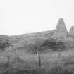
Photographs and Off-line Digital Images |
RC 3342 |
List C Survey |
General view |
1975 |
Item Level |
|
|
Photographs and Off-line Digital Images |
RC 913/23 |
Records of the Scottish National Buildings Record, Edinburgh, Scotland |
General view |
7/1961 |
Item Level |
|
|
Photographs and Off-line Digital Images |
RC 915/26 |
Records of the Scottish National Buildings Record, Edinburgh, Scotland |
General view |
7/1961 |
Item Level |
|
|
Photographs and Off-line Digital Images |
RC 914/25 |
Records of the Scottish National Buildings Record, Edinburgh, Scotland |
General view |
7/1961 |
Item Level |
|
|
Photographs and Off-line Digital Images |
RC 914/24 |
Records of the Scottish National Buildings Record, Edinburgh, Scotland |
General view |
7/1961 |
Item Level |
|
|
Photographs and Off-line Digital Images |
C 97274 S |
|
General view |
c. 1970 |
Item Level |
|
|
Manuscripts |
MS 726/167 |
Records of CFA Archaeology Ltd, archaeologists, Musselburgh, East Lothian, Scotland |
Coastal Assessment Survey: Inner Moray Firth, Volumes 1 and 2. |
14/12/1998 |
Item Level |
|
|
Photographs and Off-line Digital Images |
E 94925 PO |
Papers of James Sloan Bone, landscape historian, Inverness, Highland, Scotland |
Oblique aerial photograph of Chanonry Point taken from the WNW. |
30/12/2000 |
Item Level |
|
|
Manuscripts |
MS 2776/1/4 |
Historic Scotland Archive Project |
Survey archive: Site record sheets, site record sheets with field notes and monument forms from the Inner Moray Firth (Moray, Beauly and Cromarty Firth) Coastal Assessment Survey. Sheet 4. |
9/1998 |
Item Level |
|
|
Prints and Drawings |
BD 104/1/4 |
Historic Scotland Archive Project |
Survey archive: 1:25,000 OS Pathfinder map depicting site locations from the Moray, Beauly and Cromarty Firth Coastal Assessment Survey. Sheet 4. |
9/1998 |
Item Level |
|
 |
On-line Digital Images |
SC 1643136 |
List C Survey |
General view |
1975 |
Item Level |
|
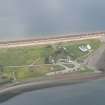 |
On-line Digital Images |
DP 340974 |
Papers of James Sloan Bone, landscape historian, Inverness, Highland, Scotland |
Aerial view of Chanonry Point, Black Isle, looking NE to lighthouse, pier & cottages. |
21/10/2007 |
Item Level |
|
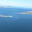 |
On-line Digital Images |
DP 343544 |
Papers of James Sloan Bone, landscape historian, Inverness, Highland, Scotland |
An oblique aerial view of the Moray Firth, showing Chanonry Point and Fort George, looking NE. |
8/4/2015 |
Item Level |
|
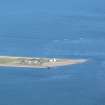 |
On-line Digital Images |
DP 343545 |
Papers of James Sloan Bone, landscape historian, Inverness, Highland, Scotland |
An oblique aerial view of Chanonry Point, Fortrose, Black Isle, looking NE. |
8/4/2015 |
Item Level |
|
 |
On-line Digital Images |
SC 2366121 |
Records of the Ordnance Survey, Southampton, Hampshire, England |
Chanonry Point, Ice House, NH75NW 55, Ordnance Survey index card, Recto |
c. 1958 |
Item Level |
|
|
Photographs and Off-line Digital Images |
BS 97/4 CS |
Historic Scotland Archive Project |
Survey photographs: From the Moray, Beauly and Cromarty Firth Coastal Assessment Survey - Avoch, Fortrose and Chanonry Point. |
1998 |
Batch Level |
|


