
Pricing Change
New pricing for orders of material from this site will come into place shortly. Charges for supply of digital images, digitisation on demand, prints and licensing will be altered.
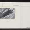
Caird's Cave


Cave (Prehistoric) - (Post Medieval)
Site Name Caird's Cave
Classification Cave (Prehistoric) - (Post Medieval)
Canmore ID 14369
Site Number NH75NW 5
NGR NH 7447 5947
Datum OSGB36 - NGR
Permalink http://canmore.org.uk/site/14369


- Council Highland
- Parish Rosemarkie
- Former Region Highland
- Former District Ross And Cromarty
- Former County Ross And Cromarty
NH75NW 5 7447 5947.
(NH 7448 5947) Caird's Cave (NR)
OS 6" map, (1959)
Caird's Cave is a rock shelter which was inhabited as late as the opening years of the present century. It was excavated by Dr Maclean, in 1912, when implements of bone, stone and deer horn were recovered including a bone pin inset with amber and of post Roman date (Stevenson 1955).
Finds in the National Museum of Antiquities of Scotland (NMAS), accession no. HM 237.
Proc Soc Antiq Scot 1931; R B K Stevenson 1955; A A Woodham 1956.
Caird's Cave, situated at the base of a cliff about 20ft OD and approx 14.0m from the shore line, is 9.2m deep, and about 4.0m high and 10.0m wide at the entrance, which is partially blocked by a rock fall. Large midden deposits containing shells and some animal bones lie in front of the cave, and close to these are the remains of an irregulary-shaped building 4.0m x 3.0m and 1.0m high.
Resurveyed at 1/2500
Visited by OS (NKB) 16 March 1966
This has been a desk assessment area.
J Wordsworth, SSSIs, Scottish Natural Heritage, 1993.
Excavated rock shelter; stone structure (AP).
No threat.
CFA/MORA Coastal Assessment Survey 1998.
Field Visit (June 1979)
Caird's Cave, Rosemarkie NH 744 594 NH75NW 5
This cave is situated by the shore of the Moray Firth 1.7km NNE of Rosemarkie. It measures about 4m in height by 10m in width at the entrance and extends for a distance of 9m; a shell-mound and what are probably the remains of an animal-pen of no great age lie in front of it. In 1912 excavations produced numerous artefacts of stone, antler and bone (NMAS HM 234-77), including a post-Roman ball-head pin inset with amber.
RCAHMS1979, visited June 1979
Transactions of the Inverness Scientific Society and Field Club, viii, 1912-18, 42-3; PSAS, lxv, 1930-1, 412; Stevenson 1955, 286; Woodham 1956, 85, 93, no. 56.
Excavation (21 June 2010 - 3 July 2010)
NH 7458 5950 Between 21 June and 3 July 2010 the Rosemarkie Caves Project undertook an excavation at Caird’s Cave, near Rosemarkie, on the Black Isle. It has long been suspected that this cave was the one excavated by Dr William Maclean and Colonel William Hall between 1907 and 1912, but their excavation was not published and no primary records survive that directly relate their excavations to Caird’s Cave. Maclean and Hall’s excavations yielded an important assemblage of bone working debris and bone tools, including an exceptionally fine amber inlaid pin, which was donated to the NMS, after Maclean’s death by his widow, Louisa. Maclean initially believed his discoveries to date from the Palaeolithic, but an obituary published in the Ross-Shire Journal on 12 December 1930 suggests the finds were Mesolithic. These dates are conjecture and the amber inlaid pin is currently considered to date from the 8th or early 9th centuries AD (S Foster pers. comm.). It is, however, unclear how the amber inlaid pin related to the other archaeological remains that were identified. More recently in 1992, the construction of a footpath disturbed the remains of a ‘stone age midden’ in front of the cave, indicating that some archaeological remains were present at the cave.
The current excavation programme was designed to clarify three key issues:
• if Caird’s Cave was excavated by Maclean and Hall
• the extent of any previous excavations
• the date, character and state of preservation of any surviving archaeological deposits.
To these ends, five excavation trenches were opened within and around Caird’s Cave. These excavations revealed that the cave had previously been extensively excavated, and artefacts recovered indicate this occurred in the early 20th century. These excavations removed c70m³ of deposits from the cave’s interior and created a large spoil heap in front of the cave; the latter is likely to be the ‘midden’ disturbed in the 1990s. The spoil heap was composed of redeposited talus and occupation deposits rich in charcoal and marine shell. A plain bone pin and bone working debris comparable to material held in the Maclean Collection were also recovered. The current excavators are therefore confident that they have located the site of Maclean and Hall’s excavation.
The excavations also revealed the presence of in situ stratified deposits within the NE half of the cave. These deposits were comparable to the material in the spoil heap and yielded a further bone pin. Three radiocarbon dates were obtained from bone and charcoal present within this sequence. These dates indicate the base of the stratigraphic sequence dates from the 4th or 3rd century BC, while the top of the sequence dates from the 2nd or 3rd century AD. This indicates higher deposits, of Early Historic and later date, were entirely removed by Maclean and Hall’s excavation. Additional dating on worked bone and antler artefacts from Maclean’s collection provided evidence of activity in the 2nd or 3rd century AD, 7th or 8th century AD and the post-medieval/modern periods.
Beyond the spoil heap a small stone structure was investigated. This structure exhibited several construction phases, but no clear ground-plan could be discerned. The use of lime mortar in the first phase indicates the structure probably dates from the 19th or early 20th century.
Archive: Rosemarkie Caves Project (currently) and NMS (intended)
Funder: Highland Council Black Isle Ward Discretionary Fund, Highland LEADER 2007-13, The Cromarty Firth Port Authority, The Cromarty Trust, Groam House Museum, Fortrose and Rosemarkie Common Good Fund, Workers’ Education Association (North Highland Local Association), Mr Neil MacKinnon and Mr Donald Cameron
Rosemarkie Caves Project, 2010

