
Newbarns


Cropmark(S) (Period Unknown), Linear Feature(S) (Period Unassigned), Roundhouse (Prehistoric), Square Barrow (Iron Age)(Possible), Sunken Floored Building (Period Unassigned)
Site Name Newbarns
Classification Cropmark(S) (Period Unknown), Linear Feature(S) (Period Unassigned), Roundhouse (Prehistoric), Square Barrow (Iron Age)(Possible), Sunken Floored Building (Period Unassigned)
Canmore ID 143598
Site Number NO64NE 72
NGR NO 6785 4978
Datum OSGB36 - NGR
Permalink http://canmore.org.uk/site/143598


- Council Angus
- Parish Inverkeilor
- Former Region Tayside
- Former District Angus
- Former County Angus
NO64NE 72 6785 4978.
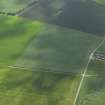
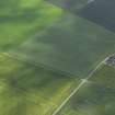
Oblique aerial photographs (RCAHMSAP 1995) show the cropmarks of a possible square barrow, and linear cropmarks stretching SW-NE, 500m N of Newbarns cottages. The barrow measures about 10m by 10m.
Information from RCAHMS (KJ) 15 April 1999.
The maculae to the N of the square barrow probably represent the remains of buildings, that to the W being a sunken-floored roundhouse also about 10m in diameter. The easternmost cropmark is rectangular and could be a smaller sunken-floored building about 4m on a side. The linear cropmarks to the S could represent a track about 10m wide with perpendicular field boundaries to its S.
Information from RCAHMS (SMDG) 6 January 2005

