
Newbarns


Cropmark(S) (Period Unknown), Enclosure (Period Unknown), Palisaded Enclosure (Period Unknown), Pit(S) (Period Unknown)
Site Name Newbarns
Classification Cropmark(S) (Period Unknown), Enclosure (Period Unknown), Palisaded Enclosure (Period Unknown), Pit(S) (Period Unknown)
Canmore ID 143595
Site Number NO64NE 70
NGR NO 6803 4963
NGR Description centred on 6803 4963
Datum OSGB36 - NGR
Permalink http://canmore.org.uk/site/143595


- Council Angus
- Parish Inverkeilor
- Former Region Tayside
- Former District Angus
- Former County Angus
NO64NE 70 6803 4963 centred on 6803 4963
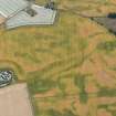
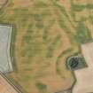
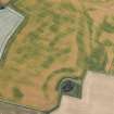
Oblique aerial photographs (RCAHMSAP 1995) show the cropmarks of two enclosures and pits, 300m N of Newbarns cottages. The larger enclosure (NO c.6803 4963) is subcircular in shape, and measures about 80m in diameter. It is cut by two linear cropmarks, and at least two pits are visible at the edge of the enclosure. A smaller oval enclosure (NO c.6748 4954) is situated about 50m to the SW.
Information from RCAHMS (KJ) 15 April 1999.
Information to follow.
RCAHMS (KB) 25 April 2000

