
Pricing Change
New pricing for orders of material from this site will come into place shortly. Charges for supply of digital images, digitisation on demand, prints and licensing will be altered.
Rattray, Castle Hill


Pillbox (20th Century)
Site Name Rattray, Castle Hill
Classification Pillbox (20th Century)
Alternative Name(s) Rattray Head Anti-tank Line; Starnakeppie
Canmore ID 143447
Site Number NK05NE 24
NGR NK 0881 5800
Datum OSGB36 - NGR
Permalink http://canmore.org.uk/site/143447


- Council Aberdeenshire
- Parish Crimond
- Former Region Grampian
- Former District Banff And Buchan
- Former County Aberdeenshire
NK05NE 24 0881 5800
For other components of the anti-tank line see NK05NE 17.00, NK06SE 10.00, NK15NW 1.00 and NK15SW 6.00
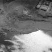
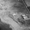
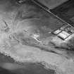
A type 24 pillbox is situated on the northern edge of the mound of Castle Hill (NK05NE 4). Part of a chain of pillboxes protecting the coast and Rattray (Crimond) airfield (NK05NE 16). The pillbox can be seen in several photographs taken during the excavation of Castle Hill during 1989. (also visible on post-war RAF vertical air photographs (106G/Scot/UK 107, 3002-3, 23 may 1946)
Information from RCAHMS (DE) April 1999.

