
Following the launch of trove.scot in February 2025 we are now planning the retiral of some of our webservices. Canmore will be switched off on 24th June 2025. Information about the closure can be found on the HES website: Retiral of HES web services | Historic Environment Scotland
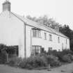
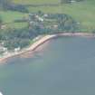
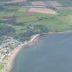
Rosemarkie, Mill


Mill (Period Unassigned)
Site Name Rosemarkie, Mill
Classification Mill (Period Unassigned)
Alternative Name(s) Rosemarkie, 1 Marine Terrace; Rosemarkie, The Old Mill; Rosemarkie Burn
Canmore ID 14344
Site Number NH75NW 27
NGR NH 73790 57750
Datum OSGB36 - NGR
Permalink http://canmore.org.uk/site/14344


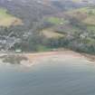
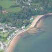
- Council Highland
- Parish Rosemarkie
- Former Region Highland
- Former District Ross And Cromarty
- Former County Ross And Cromarty
NH75NW 27 7378 5774
Mill building - outside survey area.
19th century AD or earlier.
CFA/MORA Coastal Assessment Survey 1998.

