
Fort Augustus - Bernera Military Road, Strath Cluanie And Glen Moriston


Military Road (18th Century)
Site Name Fort Augustus - Bernera Military Road, Strath Cluanie And Glen Moriston
Classification Military Road (18th Century)
Alternative Name(s) Fort Augustus-bernera Military Road; Ceannacroc Lodge
Canmore ID 143168
Site Number NH11SE 4
NGR NH 1800 1082
NGR Description NH 1999 1127 to NH 1500 1044
Datum OSGB36 - NGR
Permalink http://canmore.org.uk/site/143168

- Council Highland
- Parish Urquhart And Glenmoriston
- Former Region Highland
- Former District Inverness
- Former County Inverness-shire
NH11SE 4.00 1999 1127 to 1500 1044 MR 12 (formerly Lin 510)
NH11SE 4.01 1909 1097 Ford
NH11SE 4.02 1708 1080 Ford
NH11SE 4.03 1613 1070 Ford
NH11SE 4.04 1608 1068 Ford
NH11SE 4.05 1987 1118 Ford
NH11SE 4.06 1921 1098 Ford
NH11SE 4.07 1873 1087 Ford
NH11SE 4.08 1857 1080 Ford
NH11SE 4.09 1854 1080 Ford
NH11SE 4.10 1848 1079 Ford
NH11SE 4.11 1822 1076 Ford
NH11SE 4.12 1806 1081 Ford
NH11SE 4.13 1791 1084 Ford
NH11SE 4.14 1780 1087 Ford
NH11SE 4.15 1736 1082 Ford
NH11SE 4.16 1682 1080 Ford
NH11SE 4.17 1659 1077 Ford
Continues as NH21SW 6.00.
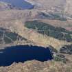
The military road continues W as a track, gradually descending to the present road by the side of Loch Cluanie at NH 156 104.
W Taylor 1976.
The military road is a roughly engineered hill track as far as NH 162 107. From this point to NH 150 103 the road is largely overlaid by modern tarmac.
Visited by OS (JB) 30 April 1979.
NH 1999 1127 to NH 1630 1070 military road now a grass- and heather-covered track 5.3m average width with occasional stretches of revettment on lower side. No evidence of military bridges. Unsuitable for wheeled transport.
NH 1916 1097 to NH 1910 1097 road indistinguishable for about 50m.
NH 1909 1097 possible ford (NH11SE 4.01).
NH 1708 1080 small paved ford (NH11SE 4.02), probably military.
NH 1630 1070 modern road crosses here.
NH 1628 1069 to NH 1521 1042 modern road generally on line of military road.
NH 1618 1070 to NH 1595 1063 heather-covered track on line of military road.
NH 1613 1070 possible ford (NH11SE 4.03).
NH 1608 1068 possible ford (NH11SE 4.04).
NH 1521 1042 to NH 1500 1044 heather-covered track on line of military road.
Visited by OS May 1964 and April 1979.
The line of the military road as described by Taylor (1976) and the OS (May 1964 and April 1979) as it rejoins the present road is probably the same, with Taylor?s grid reference being incorrect.
Information from RCAHMS (MW) 30 March 1999.
The military road initially heads W as a rough stony track passing through rugged terrain until rejoining the line of the modern road at NH 1628 1069. The track suffers from a good deal of water erosion and passage is almost impossible in wet weather due to the spating of burns running down Creag na Mairt. There is little original road fabric extant and in parts there is only bedrock and stony debris where the track surface has has been totally washed away.
This section is of interest, nevertheless, in that a number of early drainage features, principally well-made cobbled and paved fords in differing states of preservation, still survive along the route. There are also the remains of two early bridges and sections of revetting which probably formed part of the original construction of the road. From approximately NH 1628 1069 heading W the military road is overlain by the A87.
M Logie (Highland Council) 1997; NMRS MS/1007/6.
Scheduled as part of 'Fort Augustus-Bernera Military Road, 1890m W of Ceannacroc Lodge... a stretch of mid-18th-centry military road which now survives as a grass- and heather-covered track. The stretch of road is 6km long and averages 5.3m in width, with occasional stretches of revetment on the lower side.'
[Attached map indicates Scheduled length as extending from NH 1628 1070 to NH 2189 1152].
Information from Historic Scotland, scheduling document dated 27 September 2007.

