
Pricing Change
New pricing for orders of material from this site will come into place shortly. Charges for supply of digital images, digitisation on demand, prints and licensing will be altered.
Redden Haugh


Pit(S) (Period Unassigned)
Site Name Redden Haugh
Classification Pit(S) (Period Unassigned)
Canmore ID 142777
Site Number NT73NE 56
NGR NT 776 390
Datum OSGB36 - NGR
Permalink http://canmore.org.uk/site/142777


- Council Scottish Borders, The
- Parish Sprouston
- Former Region Borders
- Former District Roxburgh
- Former County Roxburghshire
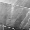
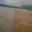
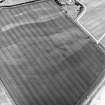
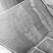
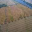
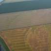
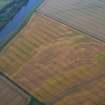
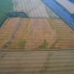
A scatter of pits has been revealed by cropmarks recorded on aerial photographs on Redden Haugh. The pits are of unknown date and function.
Text prepared by RCAHMS as part of the Accessing Scotland's Past project
NT73NE 56 776 379.
Aerial photography (RCAHMSAP 1995) has revealed the cropmarks of a series of pits 350m NNE of Redden farmsteading (NT73NE 55). What appears to be a four-poster setting lies at NT c.7770 3792 and is approximately 6m square. Cropmarks of ring-ditches and enclosures (NT73NE 40) have been recorded in the same field.
Information from RCAHMS (KB) 1 April 1999
Sbc Note
Visibility: This site is visible as a cropmark.
Information from Scottish Borders Council

