
Pricing Change
New pricing for orders of material from this site will come into place shortly. Charges for supply of digital images, digitisation on demand, prints and licensing will be altered.
Sanday, Greod


Archaeological Landscape (Period Unassigned)
Site Name Sanday, Greod
Classification Archaeological Landscape (Period Unassigned)
Alternative Name(s) Druim An Lochain; Canna
Canmore ID 142699
Site Number NG20SE 83
NGR NG 2691 0438
NGR Description NG 2691 0438 to NG 2926 0402
Datum OSGB36 - NGR
Permalink http://canmore.org.uk/site/142699

- Council Highland
- Parish Small Isles
- Former Region Highland
- Former District Lochaber
- Former County Inverness-shire
NG20SE 83.00 2691 0438 to 2926 0402
NG20SE 83.01 NG 2691 0438 to NG 2807 0438 Field-system; Lazy-beds; Field Clearance Cairns
NG20SE 83.02 NG 2807 0438 to NG 2926 0402 Field-system; Lazy-beds; Field Clearance Cairns
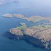
An estate map of Canna dated to 1805 shows the island of Sanday divided into two by a boundary that runs from N to S in a reverse S-shape across the neck of ground between Tallabric and Cnoc an Tionail. The eastern unit is the larger of the two and is annotated as the ?Lower Island?, while the western unit covers the remaining quarter of Sanday and is annotated as the ?Upper Island? (for which, see NG20SE 82). By 1805 both units appear to be operating as separate farms, whose boundaries probably equate with the lands previously held by two townships. The 1805 estate map depicts the buildings of the ?Lower Island? township nestling below the rocky knoll of Creag Liath (NG20SE 24), together with a splayed L-shaped range (NG20SE 63) adjacent to the N end of the boundary between the two units. The surviving rentals for Canna show that the ?Lower Island? had ceased to exist as a separate farm by 1818.
The areas of ground which were under cultivation in 1805 are also identified on the estate map. By and large there is a fairly good correlation between the areas of cultivated ground shown on this map and the surviving plots of lazy-beds. By 1881, however, the extent of the cultivated ground had been reduced significantly, and the area of improved ground depicted on the 1st edition of the OS 6-inch map (Argyllshire, 1881, sheets lix and lx) is almost identical to that shown on the 1975 edition of the 1:10,000 map; much of the latter falls within land still held in the crofts. The extent of arable ground reflects the distribution of the population, recorded in part by the rentals and census return figures for the early to mid-nineteenth century. Between these dates, the islands witnessed: the rise of the kelp-making industry on Sanday and its subsequent collapse in the 1820?s; the emigration of almost half the combined population between 1821 and 1831; and the eviction in 1851 of the tenants from ?Keill? (A? Chill) on Canna to Sanday. Together, these figures suggest that the maximum extent of cultivated ground occurred after the publication of the 1805 estate map and the mid-nineteenth century, and that there had been a dramatic contraction by 1881.
The ?Lower Island? is divided into two by a wall that cuts across a narrow neck of ground to the NE of Suileabhaig (NG 2691 0438 to NG 2806 0438). This wall appears to separate the main area of arable to the W from the main area of pasture to the E. These two areas are described separately under NG20SE 83.01 and NG20SE 83.02 respectively.
Information from RCAHMS (ARG), 22 December 1998.
J L Campbell 1984.

