
Three Mile Wood


Pit(S) (Period Unknown)
Site Name Three Mile Wood
Classification Pit(S) (Period Unknown)
Canmore ID 142675
Site Number NO63NW 24
NGR NO 6057 3910
Datum OSGB36 - NGR
Permalink http://canmore.org.uk/site/142675


- Council Angus
- Parish Arbirlot
- Former Region Tayside
- Former District Angus
- Former County Angus
NO63NW 24 6057 3910
Site recorded during an archaeological evaluation carried out prior to proposed road improvements, through a combination of desk-based research, non-invasive and invasive fieldwork
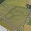
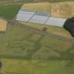
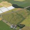
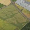
NO 6057 3910 Three Mile Wood (Balcathie). A suite of features, aligned NE-SW, were visible on aerial photographs extending into the affected area. Trenches concentrated at these points revealed a number of features on the edge of a terrace above ground sloping down to Three Mile Burn. These mainly comprised deep pits, two of which contained prehistoric pottery and small amounts of burnt bone.
Detailed reports will be lodged with the NMRS.
Sponsor: Angus Council.
A R Rees and K Cameron 1998

