
Following the launch of trove.scot in February 2025 we are now planning the retiral of some of our webservices. Canmore will be switched off on 24th June 2025. Information about the closure can be found on the HES website: Retiral of HES web services | Historic Environment Scotland
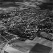
Forfar, 8-48 Lour Road


Terraced House(S) (19th Century) - (20th Century)
Site Name Forfar, 8-48 Lour Road
Classification Terraced House(S) (19th Century) - (20th Century)
Canmore ID 142480
Site Number NO45SE 149
NGR NO 4577 5039
Datum OSGB36 - NGR
Permalink http://canmore.org.uk/site/142480


- Council Angus
- Parish Forfar
- Former Region Tayside
- Former District Angus
- Former County Angus
NO45SE 149 4577 5039
The terraced houses at 8-48 Lour Road are not depicted on the OS 1:2500 map of 1894 but are shown on the OS 1:2500 map published in 1902.
Information from RCAHMS (SC) 22nd June 2009
Built in 1877.

