|
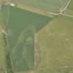
Photographs and Off-line Digital Images |
IN 5505 |
RCAHMS Aerial Photography |
Oblique aerial view. |
1982 |
Item Level |
|
|
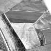
Photographs and Off-line Digital Images |
IN 5506 |
RCAHMS Aerial Photography |
Oblique aerial view. |
1982 |
Item Level |
|
 |
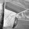
On-line Digital Images |
DP 166611 |
RCAHMS Aerial Photography Digital |
Oblique aerial view of the cropmarks of the ring ditches and pits, looking ESE. |
14/7/2013 |
Item Level |
|
 |
On-line Digital Images |
SC 1696078 |
RCAHMS Aerial Photography |
Oblique aerial view. |
1982 |
Item Level |
|
 |
On-line Digital Images |
SC 1696079 |
RCAHMS Aerial Photography |
Oblique aerial view. |
1982 |
Item Level |
|
 |
On-line Digital Images |
SC 2365808 |
Records of the Ordnance Survey, Southampton, Hampshire, England |
Redhill, NH74NW 46, Ordnance Survey index card, Recto |
c. 1958 |
Item Level |
|


