
Pricing Change
New pricing for orders of material from this site will come into place shortly. Charges for supply of digital images, digitisation on demand, prints and licensing will be altered.
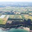
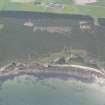
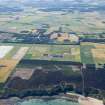
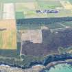
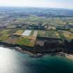
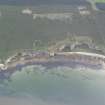
Covesea Hill


Radio Mast(S) (20th Century), Radio Station (20th Century)
Site Name Covesea Hill
Classification Radio Mast(S) (20th Century), Radio Station (20th Century)
Canmore ID 142092
Site Number NJ17SE 11
NGR NJ 1775 7035
NGR Description NJ 1775 7035 and NJ 1723 7005
Datum OSGB36 - NGR
Permalink http://canmore.org.uk/site/142092


- Council Moray
- Parish Drainie
- Former Region Grampian
- Former District Moray
- Former County Morayshire
NJ17SE 11 NJ 1775 7035 and NJ 1723 7005
Radio station visible on oblique aerial photographs (RAF 541/431, 3, 4, 15-17, 19-20, flown 1950). The station is situated on rough ground to the W of Covesea and is depicted on the current chart copy edition of the OS 1:10560 map (1968).
Information from RCAHMS (DE), March 1999.

