
Following the launch of trove.scot in February 2025 we are now planning the retiral of some of our webservices. Canmore will be switched off on 24th June 2025. Information about the closure can be found on the HES website: Retiral of HES web services | Historic Environment Scotland
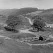
Clattering Bridge


Road Bridge (Period Unassigned)
Site Name Clattering Bridge
Classification Road Bridge (Period Unassigned)
Alternative Name(s) Clatterin' Brig; Devilly Burn; Knowegreens Burn
Canmore ID 141949
Site Number NO67NE 57.01
NGR NO 66504 78185
Datum OSGB36 - NGR
Permalink http://canmore.org.uk/site/141949


- Council Aberdeenshire
- Parish Fordoun
- Former Region Grampian
- Former District Kincardine And Deeside
- Former County Kincardineshire
NO67NE 57.01 66504 78185
Clattering Bridge [NAT]
OS (GIS) MasterMap, May 2010.
On this 1961 bridge, known as Clattering Bridge and carrying the military road across the Knowegreens Burn, there is a plaque stating that it is on the site of the Clatterin' Brig of 1780. There is no trace of military work.
Visited by OS, August 1971.
This bridge carries the B974 public road over the Knowegreens or Devilly Burn.
Information from RCAHMS (RJCM), 26 May 2010.

