
Pricing Change
New pricing for orders of material from this site will come into place shortly. Charges for supply of digital images, digitisation on demand, prints and licensing will be altered.
Ardrishaig Harbour, Pier


Pier (18th Century) - (19th Century) (1800)
Site Name Ardrishaig Harbour, Pier
Classification Pier (18th Century) - (19th Century) (1800)
Alternative Name(s) Harbour
Canmore ID 141621
Site Number NR88NE 75
NGR NR 85373 85388
Datum OSGB36 - NGR
Permalink http://canmore.org.uk/site/141621


- Council Argyll And Bute
- Parish South Knapdale
- Former Region Strathclyde
- Former District Argyll And Bute
- Former County Argyll
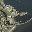
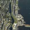
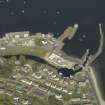
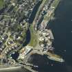
NR88NE 75 85373 85388.
This pier, located to the N of the entrance to the Crinan Canal at Ardrishaig, was completed in March 1837.
J Lindsay 1968.
This pier is clearly visible on the aerial photograph of Ardrishaig from SE.
RCAHMS 1992.
This structure is clearly marked as a pier on the 1st edition of the OS 6-inch map (Argyllshire 1873, sheet clxx), on the 2nd edition of the OS 6-inch map (Argyllshire 1900, sheet clxxNE), on the current edition of the OS 1:10000 map (1981) and on the OS 1:10000 raster map (ND).
Information from RCAHMS (MD) 12 July 2001.

