
Following the launch of trove.scot in February 2025 we are now planning the retiral of some of our webservices. Canmore will be switched off on 24th June 2025. Information about the closure can be found on the HES website: Retiral of HES web services | Historic Environment Scotland
Sheriff Muir


Military Training Site (19th Century), Military Training Site (First World War), Military Training Site (Second World War), Trench(S) (First World War)
Site Name Sheriff Muir
Classification Military Training Site (19th Century), Military Training Site (First World War), Military Training Site (Second World War), Trench(S) (First World War)
Alternative Name(s) Whitestone Range; Black Hill; Sheriffmuir; Harperstone
Canmore ID 141550
Site Number NN80SW 23
NGR NN 8378 0367
NGR Description Centred NN 8378 0367
Datum OSGB36 - NGR
Permalink http://canmore.org.uk/site/141550


- Council Stirling
- Parish Dunblane And Lecropt
- Former Region Central
- Former District Stirling
- Former County Perthshire
Field Visit (27 November 1998)
NN80SW 23.00 centred 8378 0367
NN80SW 23.01 NN 8379 0367 Atlantic Wall; Bunker
NN80SW 23.02 NN 8365 0345 Bunkers; Trenches; Gun-emplacements
NN80SW 23.03 NN 8360 0310 Rifle Range; Bunkers
NN80SW 23.04 NN 8350 0370 Trackway; Gun-emplacements
NN80SW 23.05 NN 8405 0405 Depot; Tramway
NN80SW 23.06 NN 8379 0367 Enclosures; Rig; Trackways
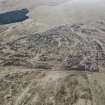
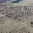
An extensive area of redundant military works is preserved in part of the inactive Whitestone Range beside the public road across Sheriff Muir. The site lies on a terrace at about 295m OD in a patchwork of rank heather and rough grass pockmarked by shell impact craters. Remains of 18th century landuse, including rig, enclosures and trackways, are scattered across the terrace (NN80SW 23.06).
The military remains in the Whitestone Range represent a complex overlay of about 100 years of use. Between about 1860 and 1906 it was one of ten Militia and Volunteers ranges and training grounds in the Tillicoultry to Dollar area. In 1907 the annual training camp of The Argyll and Sutherland Brigade of the Volunteers took place on Sheriff Muir and a four lane rifle range (NN80SW 23.03) at the S end of the site may date to this period. During World War I the 52nd (Lowland) Division trained on the range before going to Gallipoli in 1915. They are likely to have started a system of trenches (NN80SW 23.02), which may have been extended by Second Line or Reserve Battalion training drafts of men destined for France throughout World War I. Shell holes on the flank of Black Hill may originate in this period as the 4th Lowland Howitzer Brigade Royal Artillery of the 52nd (Lowland) Division were stationed in Stirling and Tillicoultry in 1914/15.
The most spectacular remains relate to a mock-up of the German anti-invasion beach defences built along the Atlantic seaboard of the Continent during World War II. This was one of a number of such practice works (Shepheard 1994, Thomas 1995) constructed during 1943 as part of the intensive rehearsals for the Allied D-Day landings. The 49th and the 52nd (Lowland) Divisions trained in the area in 1943-44, along with the 1/4th King's Own Yorkshire Light Infantry, based in Crieff. Mock-ups of German coastal defences were also built near Muthill by the 294 Field Company Royal Engineers. The World War II constructions look as if they are broadly of one piece. The main defensive elements (e.g. German positions) comprise a section of reinforced concrete Atlantic Wall, fronted by an anti-tank ditch (NN80SW 23.01). Bunkers and gun emplacements are linked by a trench system (NN80SW 23.02) that makes use of, and extends, the World War I trenches. Other remains include offensive positions (NN80SW 23.04) and what may have been the depot (NN80SW 23.05) where raw materials for construction were handled. Any modification of the range during the Cold War has not left much trace, and the range is now to all intents and purposes, closed.
Visited by RCAHMS (DCC) 27 November 1998 with Information from Dr Diana Henderson (The Scots at War Trust) and John Guy
C Shepheard 1994; R J C Thomas 1995
Note (19 November 2003)
[Area centred NN 8379 0369]. Scheduled as Sheriff Muir, Whitestone Range, SW of Harperstone... visible as upstanding ruins, ditches and earthworks.
Information from Historic Scotland, scheduling document dated 19 November 2003.
Project (March 2013 - September 2013)
A project to characterise the quantity and quality of the Scottish resource of known surviving remains of the First World War. Carried out in partnership between Historic Scotland and RCAHMS.
Field Visit (24 May 2016 - 30 May 2016)
NN 83720 03660 As part of the project to investigate the WW2 ‘Atlantic Walls’ around the UK, with particular focus on the complex of structures at Sheriffmuir, a GPS survey was undertaken, 24–30 May 2016. The survey broadly confirmed the findings of a 1998 RCAHMS survey of the military
archaeology on Sheriffmuir, and most of the structures recorded in 1998 are still identifiable.
Archive: NRHE (intended)
Funder: Dunblane Museum
Peta Glew – Northlight Heritage
(Source: DES, Volume 17)
OASIS Id: northlig1-370185

