
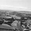
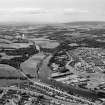
Aberdeen, River Dee


Bridge (Period Unassigned)
Site Name Aberdeen, River Dee
Classification Bridge (Period Unassigned)
Canmore ID 141171
Site Number NJ90SW 65
NGR NJ 9108 0271
Datum OSGB36 - NGR
Permalink http://canmore.org.uk/site/141171


- Council Aberdeen, City Of
- Parish Peterculter
- Former Region Grampian
- Former District City Of Aberdeen
- Former County Aberdeenshire
NJ90SW 65 9108 0271
Site recorded during a general reconnaissance in advance of a prospective archaeological field survey of uncultivated or forest ground in the Aberdeen area. Site reports will be lodged with both Aberdeen SMR and the NMRS.
NJ 9108 0271 River Dee, Bridge abutment
D I Harding 1997.

